
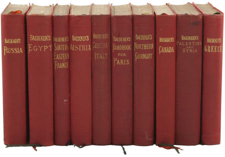
Caucasian extracts
from the first (1914) edition of
Baedeker's Russia
With Teheran, Port Arthur and Peking
—
A Handbook for Travellers
(London: David & Charles Newton Abbot
and George Allen & Unwin)
available online at http://archive.org/details/russiawithtehera00karl
Go, little book, God send thee good passage,
And specially let this be thy prayere
Unto them all that thee will read or hear,
Where thou art wrong, after their help to call,
Thee to correct in any part or all.
Route 62: From Kertch (Odessa) to Batum by Sea
Route 65: From Batum to Tiflis
Route 68: From Tiflis to Vladikavkaz
Route 69: From Vladikavkaz to Kutaïs viâ the Mamison Pass
Route 62
From Kertch (Odessa) to Batum by Sea
369 Nautical Miles. STEAMERS of the Russian Steam Navigation & Trading Co. ply from Odessa to Batum 7 times weekly in summer, calling at the Crimean ports of Eupatoria, Sebastopol, Yalta, Feodosiya, and Kertch. The direct steamer (322 S.M.; 3½ days), however, calls only at Sebastopol, Yalta, Feodosiya, Novorossisk, Tuapse, Sotchi, Gagri, and Sukhum-Kale. [The freight-steamers should be avoided.] The fares and charges for meals vary according to steamer and season. Direct mail steamer from Odessa to Novorossisk 20 rb. 55 & 14 rb. 10 cop. (food 6 rb. 40, 5 rb. 20), to Batum 31 rb. 80 & 21 rb. 90 cop. (food 9 rb. 95, 8 rb. 10 cop.). Mail steamer from Kertch to Novorossisk 5 rb. 40 & 4 rb. 35 cop. (food 1 rb. 85, 1 rb. 50 cop.), to Batum 14 rb. 50 & 11 rb. 35 cop. (food 8 rb. 25, 6 rb. 70 cop.).—A STEAMER of the Russian Transport & Insurance Co. also runs thrice weekly from Kertch (Odessa) to Novorossisk (fare 4 rb. 35), Poti (10 rb. 80), and Batum (11 rb. 35 cop.). These rates are for the second cabin (there being no first) and do not include meals.
At Novorossisk, Tuapse, Poti, and Batum the steamers lie-to at the piers, but at other points passengers are landed by small boats, if the sea is calm enough.
Kertch, see p. 426. In continuing the journey we at first see to the left the flat Peninsula of Taman, but beyond the mouth of the Kubán begin the Caucasian Mountains, which accompany the coast for a distance of 250 M. An extraordinary stillness broods over the forest-clad mountain-slopes; since the emigration of the Circassians (p. 441) no signs of human occupation are seen except a few ruined fortifications or a recent Russian settlement.
48 S.M. Anápa (Rossiya), a seaport and bathing-resort with 11,500 inhabitants.
86 S.M. Novorossísk, Новороссийск.—HOTELS. Yevrópa, Serebryakóvskaya, in the town, R. 1-3¾, D. (12-6) ¾-1 rb.; Frántziya, at the harbour, R. 1¼-5½, D. (12-6) ¾-1¼ rb.—Phaeton from the harbour (steamers land passengers on the quay) to the rail. station or to the town 35, from the old town to the station 50, per hr. 50 cop.—MOTOR OMNIBUS from the rail. station to the 'Kurort', as far as the Serebryakóvskaya in ¼ hr. (fare 15 cop.).—BRITISH VICE-CONSUL & LLOYD'S AGENT, O. Geelmuyden.
Novorossísk, a pleasantly situated seaport on a bay 2½ M. wide and 5 M. long, is the capital of the Government of the Black Sea, and contains 61,000 inhabitants. It has belonged to Russia since 1829. The harbour is one of the best on the whole Pontic coast, though in winter it is exposed to storms raised by a wind resembling the Bora. On the N. side of the bay lies the 'New Town', containing the buildings of the Russian Standard Petroleum Co., the rail. station (¾ M. from the harbour and 2¼ M. from the Old Town), the large grain elevator, and a Lutheran church. To the S.E. of the New Town are several cement works; a visit may be made to the quarries of the Black Sea Cement Co. (German officials). On the W. side of the bay is the 'Old Town'. Between this and the New Town lies the Tzemés Morass which is being drained. To the S. of the Old Town is the 'Kurort', with sea-bathing.—In the environs are large vineyards.
From Novorossisk to Sukhum-Kale by the Coast Road, 486 V. (322 M.). This road is provided with posting-stations (indicated below by P.; horse 6 cop. per verst), but lack of horses often causes considerable delay. A private carriage to Sukhum-Kale costs 120 rb.; motor car to Sotchi 300 rb. This is an interesting but somewhat fatiguing trip, best made in August or September. Fair accommodation is found in the larger places. The traveller must be on his guard against fever.—On leaving Novorossisk we proceed towards the S. 24 V. Kabardinskaya (P.). Beyond (39 V.) Gelendzhik (p. 449; P.) the road gradually ascends to the (60 V.) Mikháilov Pass (2625 ft.; P.). Beyond the pass it descends circuitously to the village of Beregováya.—75 V. Pshádskaya (P.).—At (94 V.) Arkhipo-Óssipovka (P.), a village of 600 inhab., once stood the Mikhailov fort, blown up in 1840 by the private soldier Arkhip Ossipov at the cost of his own life to prevent its falling into the hands of the Circassians. This deed of heroism is commemorated by a white cross in the middle of the village.—118 V. Dzhubga (p. 449; P.); 129 V. Tenginski Posád (P.); 142 V. Novo-Mikáilovskaya (P.); 154 V. Ólginskaya (P.). Beyond (173 V.) Nebúgskaya (P.) we cross the Agui. A little farther up the valley, amid an amphitheatre of mountains, is the Circassian 'aul' of Kárpovka. 191V. Tuapsé (p. 449; P.). Farther on the scenery is very imposing. 215 V. Nashé (P.); 232 V. Yelisavétinskoye (P.); 249 V. Lázarevskoye (P.); 266 V. Tchukhúkskaya (P.); 289V. Golovínskaya (P.); 301V. Vardané {V.), a grand-ducal domain; 315 V. Dagomúis (P.), an imperial domain; 332 V. Sotchi (p. 449; P.); 352 V. Hosta (P.); 364 V. Adler (p. 449; P.); 377½ V. Sandripsh (P.); 404½ V. Gagri (p. 449; P.).—419½ V. Koldokhvára (P.), in the province of Kutaïs. About 7 M. to the S. lies Pitzunda (see below).—435½ V. Svondripsh (P.); 445½ V. Gudaút (see below; P.). Beyond this point we traverse wood, passing the (461½ V.) convent of Novi Afón (p. 450; P.).—486 V. Sukhúm-Kalé (p. 450).
From Novorossisk to Tikhoryétzkaya (Rostov, Baku), see pp. 453, 452.
104 S.M. Gelendzhík (Kordes, Peterbúrgskaya, R. ¾-2 rb., D. 50-70 cop.), situated on a crescent-shaped bay, with 1800 inhab. and good bathing.—The steamer next halts at (140 S.M.) Dzhubga, 2 M. from the village of that name (1000 inhab.; road to Yekaterinodar, p. 452). The mountains now become higher.—163 S.M. Tuapsé or Velyamínovski Posád (Rossiya), a small town situated on an eminence. Pop. 16,000. The mountains here are about 3000 ft. above the sea. A railway is being built to Maikop (p. 453).
204 S.M. Sotchi, Сочи.—HOTELS. Kavkázskaya Riviera, three large buildings, overlooking the sea, with café, restaurant, and theatre, closed from Nov. 15th till Easter, R. 1½-6, déj. (12-2) ¾, D. (6-8) 1, board 45-75 rb. per month; Grand-Hôtel, R. from 1½ rb., D. (1-6) from 70 cop., pension from 65 rb. per month.—IZVÓSHTCHIK from the harbour to the Square 50 cop., per day 10-15 rb.—MOTOR SERVICE to Sukhum-Kale.
Sotchi, a town of 11,300 inhab., is noted for its luxuriant southern vegetation, and perhaps occupies the site of the ancient Nisis. It consists of an upper part on a plateau and a lower part on the river Sotchi. Pleasant walks may be taken in the Khludovski and Yermólovski parks. In the vicinity are large vineyards and orchards.
About 5 M. to the S.E. of Sotchi are the Matzestinskiye Sulphur Springs.—An excursion (taking one day by carriage) may be made to the Falls of the Matzesta. We follow the Adler road to the S.E. for 4 V., then turn to the left, and drive 13 V. more to Siverskiye Khutora. Here we leave the carriage and proceed on foot to (30-40 min.) the first waterfall, whence it takes 1½ hr. more to reach the fourth and last.
218 S.M. Adler (Yúzhnaya, overlooking the sea, R. ¾-2 rb.), at the mouth of the Mzuimtá, with 1600 inhabitants.
A road (carr. 12-15; diligence 2½ rb.) leads N.E. from Adler through the fine valley of the Mzuimtá to (54 V.) the town of Románovsk (1970 ft.; Atchishho, R. 1-2 rb.), also called Krásnaya Polyána, with 3400 inhabitants. There are several mineral springs in the vicinity. About 5 M. to the N.W. is an imperial hunting lodge.
232 S.M. Gagri.—There are four HOTELS (300 rooms), all belonging to the State. R. from 1 rb., B. 40-60, déj. (12-2) 75 cop., D. (6-8) 1½ rb.—PHAETON per drive 20-30 cop.—Saddle-horse 3 rb. daily.—Sea-bath 30 cop.
Gagri, a bathing-resort established by the Russian Government in 1901 at the instance of Alexander, Duke of Oldenburg, who built a chateau here, lies by the sea on the S. slope of the coast-mountains, and is sheltered from the N. winds. The mean annual temperature is 60° Fahr. Among the interesting walks in the vicinity are those to the Lower Fall of the Zhoekvara (1 hr.), to the Upper Fall of the Zhoekvara (3 hrs.), and to the source of the Gagripsh (1½ hr.).
Farther on appears Pitzúnda (accommodation in the Dukhán, 1 M. from the church), with a conventual church in the Byzantine style (10th cent.). This is supposed to have been the site of the Milesian colony of Pityusa ('pine town').—257 S.M. Gudaút, a small village. Luikhni, the ancient capital of Abkhasia, 2¾. M. to the N., is now an unpretending village with an old Georgian church.
260 S.M. Novi Afón (Новый Афон, 'New Athos'), a large convent of the monks of Mt. Athos, founded in 1875 (accommodation in the guest-house). An old church found here has been enlarged to serve as the convent-church, and on the highest terrace there is also an imposing cathedral, consecrated in 1900. A good view is obtained from the high-lying Iberian chapel (Иберская часовия). The vineyards and orchards are very well kept. There is a pretty walk to the waterfall and on to a cave (пешера Симона Кананита).
278 S.M. Sukhúm-Kalé.—Hotel Oriental, R. 1-5 rb.—Cab per drive 15, per hr. 40, to Sinope 40 cop., to (16 M.) Novi Afon (see above) and back 5-6 rb.—Omnibus to Novi Afon 1 rb. 20 cop.
Sukhúm-Kalé, the chief town of a district in the province of Kutaïs, lies on the flat coast-district, which is here somewhat wider than usual, and contains 25,000 inhabitants. It is surrounded on three sides by mountains, and is noted for its mild climate (mean annual temperature 59°) and rich vegetation. In the middle of the town is the Alexander Nevski Cathedral. The other chief objects of interest are the 'Sinope' Garden of the Grand-Duke Alexander Mikhailovitch and the adjoining private gardens, the Botanical Gardens, and the Public Park. A considerable traffic is carried on in tobacco.—Iskuria, the name of the promontory to the S., recalls the Milesian colony of Dioskurias (the Roman Sebastopolis).
Near Sukhum-Kale lie the small German colonies of Neudorf and Gnadenberg (E.).—Sukhum Military Road, see p. 453.
Another road leads from Sukhum-Kale viâ (58 V.) Otchemtchíri (see below) to (107 V. or 71 M.) Zugdidi, capital of Mingrelia, with 4600 inhabitants. Hence a highroad leads to (42 V.; 28 M.) Novo-Senáki (see below).
After a short halt at (306 S.M.) Otchemtchíri the steamer passes the mouth of the Ingúr. The two snow-domes of the Elbruz (p. 485) are visible here in clear weather.
340 S.M. Poti (Colchida; Bellevue; phaeton from the harbour to the rail. station 50, from the harbour to the town 40, from the station to the town 30 cop., double rates at night; electric tramway through the town; acting British vice-consul and Lloyd's Agent, John Pavoni), a town of 17,500 inhab., lies in a marshy and fever-breeding district at the mouth of the Rión, 1⅔ M. from the railway. The river is crossed by a bar of diluvial mud, and in stormy weather the steamer goes on to Batum without calling here.—To the S.E. of the town is the large Lake Paleostóm, the ancient mouth of the Rión, beside which lay the Milesian colony of Phasis.
FROM POTI TO SAMTREDI, 62 V. (41 M.), railway in 2 hrs.—The line at first traverses a flat marshy country. Beyond (15 V.) Abasha we cross the Tzkhenis-Tzkali, the Hippos of the ancients, forming the boundary between Imeretia and Mingrelia. Soon after we obtain a view to the left of the snow-capped summits of the Laila chain.—Beyond (26 V.) Novo-Senáki, the station for the district-capital of that name (4.500 inhab.), the train crosses the Tekhur at a point 8 M. below the extensive remains of Nakalakevi. We then reach the exuberantly fertile plain of the Rión, which is surrounded by hills of moderate height. Its endless fields of Indian corn make a somewhat monotonous impression. From Novo-Senaki to Sukhum-Kale, see p. 450.—At (62 V.) Samtredi (75 ft.; Rail. Restaurant) our line joins the railway from Batum to Tiflis (see p. 463).
On entering the harbour of Batum, we enjoy a magnificent view of the chain of the Caucasus and of the Adzharian Mts. in Lazistan.
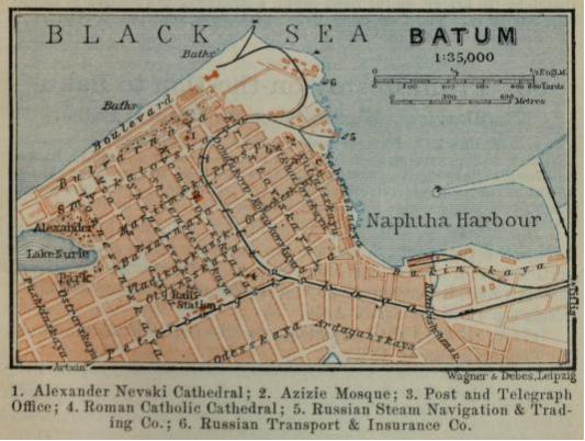
369 S.M. Batúm.—HOTELS. Impérial (Pl. a), Kutaïskaya, R. from 1½ rb., D. 60 & 80 cop.; Frántziya (Pl. b), Mikháilovskaya, D. à la carte; Oriental (PI. c), Náberezhnaya, D. 60 & 80 cop.—Summer Restaurant in the Boulevard, opposite the Cathedral, D. (12-4) ½-1 rb.—POST & TELEGRAPH OFFICE (PI. 3), Mariinski Prospékt.—Cab from the harbour or station to the town or vice versa 40, per drive 25, per hr. 80 cop.—BOAT per hr. 60 cop.—CONSULS. Great Britain, P.W.J. Stevens, Mariinski Prospékt 24; United States, L.A. Davis, Sobórnaya Square.—LLOYD'S AGENTS, F. Burkhardt & Co., Náberezhnaya.
STEAMERS to the Crimea and Odessa, see p. 447.—To Constantinople several times a week (comp. Baedeker's Mediterranean).
Batúm, the capital of a district and the most important trading town on the E. Pontic coast, lies on a marshy spot at the foot of the W. spurs of the Armenian plateau. Pop. 40,000. The town owes its importance to the railway to Baku, but its trade has dwindled since the unrest of 1905-6. The chief exports are petroleum and its by-products, manganese, liquorice, silk-cocoons, and wool. On the W. side of the Petroleum Harbour are bazaar streets, on the E. side petroleum stores. Along the stony beach runs the Boulevard, a palm-fringed street dominated on the S. by the Alexander Nevski Cathedral, built in 1906. Adjoining Lake Nurie, in the W. part of the town, is the Alexander Parky with its subtropical vegetation.
About 2 M. from Batum is a group of mediæval ruins known as Zamok Tamári, i.e. Castle of Queen Tamara (comp. p. 443).—Makhindzhaúri, 4 M. to the N., is frequented for its good air; it is a station on the railway to Tiflis.—The tea-plant and the bamboo are cultivated with some success in the Tchakva Valley (9 M.; p. 463) and in the hilly district adjoining it.—About 13 M. to the S. of Batum, and reached by an attractive bridle-path, are the interesting ruins of the old Church of Makriáli.—To Adzharis-Tzkali (phaeton there & back, in one day, 5-6 rb.; motor-car 10-12 rb.), see below.
FROM BATUM TO ARTVIN, 92 V. (61 M.), an attractive excursion. A carriage (phaeton), accomplishing the journey there & back in 3 days, may be hired for 30-35 rb.; the start has to be made betimes; motor omnibus 6 rb.; cyclists take about 10 hrs. We return to the village of Kapandidi, 6 M. to the S. of Batum, by boat (a so-called kayúka) in 6-8 hrs. (fares 5-10 rb.). The kayúkas plying daily to Kapandidi with vegetables take passengers for 2-3 rb. a head. The road, which runs almost the whole way along the right bank of the Tchorókh, crosses the valley of the Kakha-béri, to the S. of Batum.—16 V. (11 M.) Adzháris-Tzkali, a village in a pretty district, with a bridge over the Adzhára. In the vicinity is the goderski Pass, with a petrified forest.—27 V. Maradidi, a large village with a frontier-post; 32 V. Kheba; 45 V. Bortchkha, on the left bank of the Tchorókh.—Beyond (69 V.) Zinkóg we cross a bridge to (92 V.) Artvin (hotel by the bridge, on the right bank), a straggling town rising in picturesque terraces. The 7300 inhabitants speak Armenian and Turkish.
From Batum to Tiflis, see R. 65.
Route 65
From Batum to Tiflis
327 V. (217 M.). RAILWAY in 11-13 hrs. (fares 10 rb. 75, 6 rb. 45 cop.; reserved seat 1½ rb.).—This is a very attractive trip.
Batúm (Rail. Restaurant), see p. 451. The line at first follows the coast, with the Black Sea to the left, and the N. slope of the Pontic Mts. to the right. We thread a short tunnel. 13 V. Tchakva (p. 452). Beyond (52 V.) Supsa, situated on the river of that name, the train turns to the E., and enters the wide and fruitful plain of the Rión and its tributaries. This was the ancient Colchis, now Mingrelia and Imeretia.—At (99 V.) Samtredi (75 ft.; Rail. Restaurant) we are joined by the line coming from Poti (pp. 450, 451).—128 V. (85 M.) Rión (340 ft.; Rail. Restaurant). To Abbas-Tuman, see p. 492.
FROM RIÓN TO TKVIBULI, 49 V. (33 M.), railway in 4½ hrs.
8 V. Kutaïs, Кутаисъ.—Railway Restaurant.—HOTELS. Frántziya, R. 1-6 rb., B. 40 cop., D. 1 rb.; Grand-Hôtel, similar charges.—Restaurant Yalta, at the Byeli Bridge, on the Rión, D. ½-1 rb.—CAB from the rail. station to the town ½, per drive ¼, per hr. 1 rb.—Preserved fruits at Oganiezov's.—Modern Caucasian arms and shawls can perhaps be purchased more advantageously in Kutais than in Tiflis.
Kutaïs (530 ft.), a town of hoar antiquity, originally the capital of Colchis, afterwards that of Imeretia, and now that of the province of Kutaïs, is finely situated on the foaming Rión, the banks of which are here connected by three bridges. Pop. 57,000. The beautiful conifers, magnolias, laurels, and myrtles in the Nakashidze Garden and on the so-called Farm (Ферма), excite the admiration of the traveller. On the Archieréiskaya Gorá, or Bishop's Mountain (carr. & pair there and back in ¾ hr., 1 rb. 20 cop.), above the town to the N., on the right bank of the Rión, are the remains of the Church of Bargat III.(Храмъ царя Баграта III.), which was erected at the beginning of the 11th cent. in a mixed Byzantine and Armenian style. Above is a low fortress tower, which commands a good view of the town, the mountains, and the convent of Gelati
From Kutaïs to Vladikavkaz, on the Ossetian Military Koad, see R. 69; to Svanetia viâ Alpani, see p. 481 and R. 70.
16 V. (11 M.) Geláti (705 ft.), whence a rough path about 2 M. in length ascends to the E. to the convent of that name, which, however, is more conveniently reached from Kutaïs in 1¼-1½ hr. by phaeton (return-fare 6-7 rb.; provisions should be taken).—The Convent of Gelati, founded in 1109 and situated high up on the hillside, is occupied by a few Georgian monks. Its buildings are fast crumbling away. The chief church, the Cathedral of the Virgin (Храмъ Рождества Богородицы ), stands in the middle of the convent court, and dates from the end of the 11th century. It is constructed of huge blocks of sandstone and contains some faded frescoes, with portraits of the Imeretian kings. On the ikonostás are some old pictures of saints. At the corner of the apse is a large mosaic of the 11th cent., representing the Virgin with the archangels Michael (on the left) and Gabriel (on the right). The treasury (Ризница; to the right of the ikonostás), contains the Imeretian royal crown, some ancient MSS., and ecclesiastical vestments and vessels.—To the right of the cathedral is a chapel containing the tomb of King David the Restorer (1089-1125), who was the founder of the convent. To the right of the sarcophagus stands one wing of an iron gate dating from 1063, which was brought by the king from the conquered Persian town of Ganzha (Yelisavetpol). About 10 min. walk above the convent (we turn to the right on leaving the court) is the Elias Chapel, the *View from which embraces the valley of the Tzkali-Tziteli ('Red River'), an affluent of the Kviríla. This valley is bounded by the luxuriantly wooded hills of Imeretia, beyond which rise the spurs of the central chain in the districts of Letchgúm and Radshá.
About 3 M. from Gelati, on a cliff in the valley of the Tzkali-Tzitéli, lies the convent of Motzaméti, which, however, contains nothing of interest except an old sarcophagus resting upon lions' feet.
49 V. (33 M.) Tkvibúli (2090 ft.), with coal-mines.
CONTINUATION OF THE RAILWAY TO TIFLIS. The train now runs to the S.E., skirting the wooded N. slope of the Akhaltzúikh-Imeretian watershed, which here attains a height of 9515 ft.—156 V. Kviríli (520 ft.; Rail. Restaurant), situated on the Kviríla a torrent hurrying down to the Rión. From (160 V.) Sharopán (550 ft.; Rail. Restaurant) a narrow-gauge line ascends to the N., through the valley of the Kviríla, to (50 V. or 33 M.) Satchkheri, passing (38 V.) Tchiatúri (1125 ft.), near which large beds of manganese are quarried. We now leave the hot plain of Colchis and ascend abruptly over viaducts, through a narrow and verdant valley. Beyond (200 V.) Tzipa we cross the ridge of the Surám Mountains, separating the valleys of Imeretia and Georgia, by a tunnel 2⅓ M. long. At (205 V.) Varvárino (2480 ft.), the highest point on the railway between Batum and Baku, the train reaches the fertile plain of Suram, which is surrounded by lofty wooded mountains. We are now in the district of the Kurá, through which we descend gradually to—
215 V. (143 M.) Mikháilovo (2305 ft.; Railway Restaurant). The numerous oil-tanks at the station belong to the Nobel refinery at Baku. Branch-lines run to the N. to (6 V.) Suram and to the S. to (28 V.) Borzhom (p. 490).—The train crosses the Kurá and descends along its right bank. Just short of (240 V.) Kareli the high mountains begin to appear on the left, and farther on the Kazbek (p. 477) can be seen nearly 60 M. away as the crow flies.
257 V. Gori (1915 ft.; Railway Restaurant; Seméinuiye Nomerá; izvóshtchik from the rail. station to the town 40 cop.), the chief town of a district, with 20,700 inhab., nearly all of whom are Georgians. It lies on the left bank of the Kurá, at the foot of a conical hill surmounted by the ruins of the castle of Goris-Tzikhe.
High up in a cliff about 5 M. to the E. of Gori (phaeton 5-6 rb.), on the left bank of the Kurá, lies the curious cave-town of Uplis-tzikhe, containing a natural tunnel in the sandstone, about 82 yds. in length, which leads down to the level of the Kurá.
From Gori to Zaramag, see p. 485.
The character of the scenery now changes, naked and barren clifs taking the place of the wooded slopes. The parched and monotonous hill-country of Georgia gradually unfolds itself. Below rushes the Kurá in a deep gorge.—Beyond (296 V.) Xanka (Ксанка) we cross the Kurá; then we notice on the left, above the Shió Mgvinski Convent (hardly visible from the railway), numerous caves in the vertical cliffs, which are said to have afforded refuge to the Christians at the time of the inroads of the Mongols and Persians.—At (307 V.) Mtzkhet (1515 ft.; Railway Restaurant; p. 474) the railway crosses the Gruzinian Military Road. Beyond the rail. station, on the left, is the cathedral.
327 V. (217 M.) Tiflis (1490 ft.; Rail. Restaurant).
Route 66
Tiflis
The bureau of the Government Railways and the agency of the Sleeping Car Co. are in the offices of the Caucasus and Mercury Steam Navigation Co., Erivánskaya Square 3 (Pl. A, B, 4; II).
Hotels. *LONDON (Pl. a, B 1; II), Madátovskaya 9, R. 2-10 rb., B. 70 cop., déj. & D. à la carte, pens. 8-15 rb.; *ORIENT (Pl. b, A 2, II; proprietor, A. Roth), Golovinski Prospékt 9, R. 1½-10 rb., B. 50 cop., déj. (12-5) 90 cop. to 2 rb., D. (5-12) 1¼-2½, pens. 5-8 rb. (at both these hotels English, French and German are spoken); WETZEL (Pl. c, A 2; I), at the corner of Mikháilovski Prospékt and Xéniyevskaya, R. 1-10 rb., B. 60, D. (1-5) 60 cop. to 1 rb.; KAVKÁZ (Pl. d, A 3; II), Erivánskaya Square, frequented by Georgians; PALACE HOTEL, Golovinski Prospékt (Pl. A, 1-3; II), new. Hôtels Garnis. SYÉVERNUIYE NOMERÁ (Pl. c, A 3; II), Gráfskaya 1, R. ¾-6 rb.; GRAND-HÔTEL (Pl. f, B 1; II), opposite the London Hotel.
Restaurants at the hotels. Also Annóna, under the Arts Club Theatre (Pl. A, 1; II), D. (1-5) 60 cop. to 1 rb. 20 cop.; Restaurant near the Theatre of the Georgian Noblesse (Pl. A, 3; II), D. including wine 1 rb.; Beau Monde, Yelisavétinskaya (Pl. A, B, 1-3; I) cor. of Nekrásovskaya.—Among the national dishes are the following: shashlúik (p. 405), basturmá (beef roasted on the spit), tchikhirtmá (soup with mutton or fowl, saffron, and other spices), lokó (boiled fish from the Kurá), and plov (the Turkish pilau).
Cabs (two-horse phaetons).
From the rail. station to the town (if the train is more than ½ hr. | 75 cop. |
From the town to the station . . . . . . . . . . . . . . | 50 cop. |
Per drive . . . . . . . . . . . . . . . . . . . . . | 50 cop. |
Per hour . . . . . . . . . . . . . . . . . . . . . | 1 rb. |
To the Mushtaïd Gardens or to the Botanical Gardens . . . . . | 80 cop. |
Electric Tramways. The chief intersecting points are the Erivánskaya Square (Pl. B, 4; I), and the Samánnaya Square (Pl. D, 4; II).—1. From Erivánskaya Square viâ Golovínski Prospékt and the Kirótchnaya to the Railway Station (Pl. A, B, 1; I); red disk or lamp.—2. From Tzkhnétskaya (Pl. A, 3; I) viâ Erivánskaya Square and Mikháilovski Prospékt to the Railway Station; white disk.—3. From Erivánskaya Square viâ the Tcherkezovskaya (Pl. B, 2, 3; I) to the Railway Station; yellow disk.—4. From the Military Hospital viâ the Kakhetinskaya (Pl. C, 4, 5; I), Mukhránski Bridge, and Erivánskaya Square to the Railway Station; blue disk.—6. From Samánnaya Square viâ the Tcherkezovskaya to the Railway Station and back viâ Mikháilovski Prospékt (Pl. A, B, 1-3; I); green and red disk.—7. From Ortatcháli (beyond Pl. C, 5; I) viâ Samánnaya Square and Mikháilovski Prospékt to the Railway Station and back viâ the Tcherkezovskaya; yellow and blue disk.—9. From Sololáki (Pl. A, 4, 5; I) viâ Erivánskaya Square to the Olginskaya (Pl. A, 3; I); blue disk.
Post Office, Madátovskaya 5 (Pl. B, 1; II); new building under construction at the corner of the Golovínski Prospékt and Voyénnaya (Pl. A, 3; I).—Telegraph Office, Voyénnaya 4, adjoining the Posting Station.—POSTING STATION (Pl. A, 3; I), at the N. end of the Golovínski Prospékt.
Theatres. Great Imperial Theatre (Kазëннiй Teáтpъ; Pl. A 3, I), Golovínski Prospékt; Artists' Club Theatre (Teáтpъ артистическаго общества; Pl. A 1, II), near the Great Theatre; Theatre of the Georgian Noblesse (Teáтpъ грузинскаго дворянства; Pl. A 3, II), Dvortzóvaya.—Georgian Orchestra ('The Four Sazandari'), in the summer-premises of the Avlabárski Club, Mikháilovskaya (Pl. B, 3; I).
Clubs. German Club, Mikháilovski Prospékt 129 (Pl. A, 1, 2; I). Kruzhók (strangers admitted on the introduction of a member; entrance fee 1 rb. 5 cop.), Golovínski Prospékt 10 (Pl. A, 1-3; II), summer-premises in the Kirótchnaya, near the Vérinski Bridge (Pl. A, 3; I); concerts several times a week in summer, and balls in winter. Artists' Club (Pl. A, 1; II), summer address, Mikháilovski Prospékt 107 (Pl. A, 1, 2; I), with garden and concerts (50 cop.). Armenian Club (Tифлисское собрание), Golovínski Prospékt 6 (Pl. A, B, 3, 4, I; new building at the N. end of this street), summer-premises at Mikháilovski Prospékt 73 (Pl. A, B, 1-3; I).
Physicians (German-speaking). Dr. Von Haffner, Torgóvaya 10; Dr. Kirschenblatt (internal diseases), Xénievskaya 6; Dr. Maissuryánz, Loris-Mélikovskaya 9; Dr. Mykirtchyánz (ladies' doctor), Bébutov St. 58; Dr. Rosenbaum (surgeon), St. Michael's Infirmary.—DENTISTS. Helmrich, Golovínski Prospékt 41; Dr. Mykirtchyánz (see above).—BATHS at the foot of the fortress, comp, p. 470; fee to the masseur (Tëpщикъ) 30-50 cop.
Banks. Imperial Bank (Pl. A, B, 2; II), Loris-Mélikovskaya; Bank of Commerce, Erivánskaya Square (Pl. B, 4; II).
Shops (generally shut from 2 to 5 p.m. in the height of summer). Leather and Felt Goods: Adelkhanov, Armyánski Bazaar (Pl. B, C, 4; II).—Preserved Fruits, Groceries, & Foreign Wines: Nazarbékov, Dvortzóvaya, under the Theatre of the Georgian Noblesse (Pl. A, 3; II).—Underclothing: Altchvang, Dvortzóvaya (Pl. A, 3; II).—Books: Hiddekel, Golovínski Prospékt 11 (Pl. A, 2; II).—Maps of the Caucasus at the General Staff Offices (Pl. A, 3; II).—Photographs: D. Yermakov, Erivánskaya Square (Pl. B, 4; II), next door to the Kavkáz Hotel; photographic materials, Hagen, Golovínski Prospékt, adjoining the Military Museum (Pl. A, 2; II).—Sporting Guns & Revolvers: Hägele, Golovínski Prospékt 19.—Opticians: Hornig, Golovínski Prospékt, next door to the Military Museum.—Chemists: Кавказское товарищество торговли аптекарскими товарами, in the Erivánskaya Square, adjoining the Town Hall.—Bazaars, see p. 469 (Silk and Silver Ware, &c., A.N. Akopov, Armyánski Bazaar, Pl. B, C, 4, II).
Principal Attractions (1 day). Morning: Convent of St. David, Bazaars. Afternoon: Sulphur Baths, Botanical Gardens.
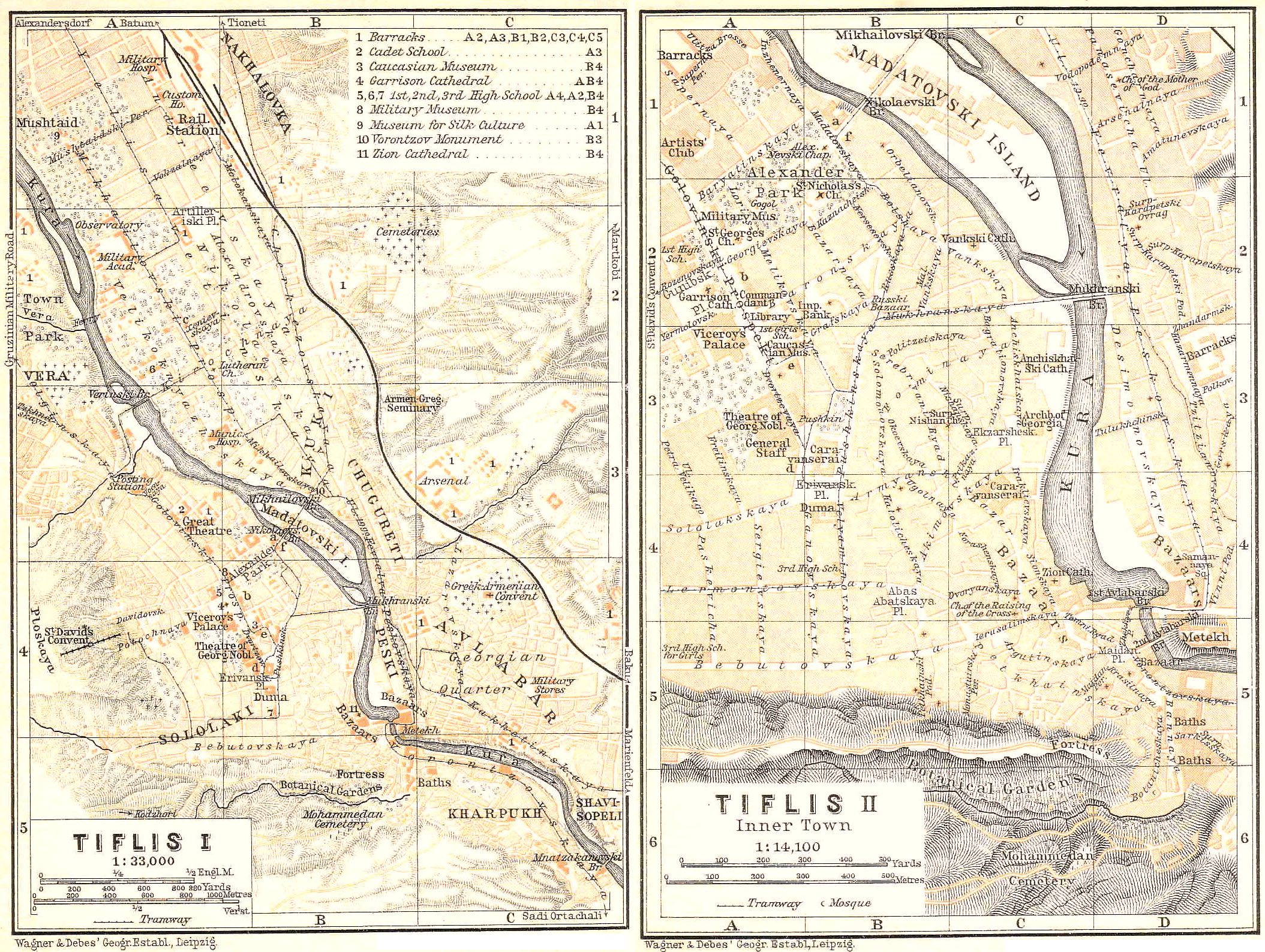
Tiflis or тифлисъ (1495 ft.), Georgian Tbilisi or Tbilizi Kalaki, the capital of the viceroyalty of the Caucasus and of the province of Tiflis, and the headquarters of the 1st and 2nd Caucasian Army Corps, stretches for a distance of about 7 M. along a narrow valley 1-1½ M. in width and enclosed by barren mountains 2300-2460 ft. in height. Pop. 350,000 (Armenians, Russians, Georgians, &c.). Latitude 41° 13' N., long. 44° 48' E of Greenwich. Through this valley the Kurá has hollowed out for itself a deep bed, and in its S.E. course through the town it has a fall of about 60 ft. On the S., where the castle-hill (1580 ft.) one the right bank is faced by a promontory on the left, the channel of the stream contracts to a width of about 100 ft. In consequence of its shut-in position, Tiflis is very hot in summer, when the mean temperature is 74° (in winter 35°, throughout the year 55°). Autumn is the pleasantest season.—Tiflis owes its prosperity to its favourable situation at the intersection of the trading routes from the Caspian to the Black Sea and from the Armenian uplands across the Caucasus to Russia. The most important of its products are carpets, woollen, cotton, and mercerized goods, shoes, wine, and tobacco.
Tiflis derives its name from the warm sulphur springs (Georgian tbili=hot) which the Georgian Tzar Vakhtang Gurgazian (446-499 A.D.) is said to have discovered while hunting. At the beginning of the 6th cent. it succeeded Mtzkhet (p. 474) as the capital of the Georgian kingdom. In 1395 Timur the Tartar plundered the town. On the division of the kingdom in 1424, Tiflis remained the capital of Karthlia, generally under the suzerainty of Persia, though at times also menaced by the Turks. In 1795 Tiflis was destroyed by the Persians, and in 1801 it was ceded to Russia.
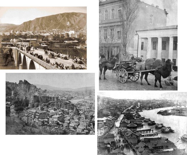
VIEWS OF TBILISI IN THE NINETEENTH CENTURY
Clockwise from top left: The Nicholas Bridge linking Madátovski Island (and, beyond it, the Alexander Gardens below Golovínski Prospékt) with the beginning of Mikháilovski Prospékt on the left bank; Bactrian camels draw carts through a street in one of Tbilisi's fashionable neighbourhoods; water-powered flour mills on the river; and a view of the fortress with the neighbourhood around the sulphur-baths at its foot.
In the N. part of the town, on the left bank of the Kurá and to the S. of the railway station, stretches the clean GERMAN QUARTER, formerly occupied by German immigrants from Wurtemberg (1818). To the S. is the GRUZINIAN or GEORGIAN QUARTER (Avlabár).—On the right bank of the Kurá is the RUSSIAN QUARTER, the seat of the officials and of the larger business firms. This is adjoined on the S. by the Armenian and Persian BAZAARS.
Perhaps the most interesting feature of Tiflis consists of the STREET SCENES in the native quarters. The streets are generally steep and often so narrow that two carriages cannot pass each other. The houses, mostly adorned with balconies, are perched one above the other on the mountain-slope, like the steps of a staircase. From sunrise to sunset, with the exception of the hot midday hours, the streets are crowded with a motley throng of men and animals, walkers, riders, and carts (arbá; p. 445). The most conspicuous elements of the population include the Georgian dealders in vegetables, fruit, and fish, with their large wooden trays on their heads; the Persians, in their long caftans and their high black fur caps, often with red-dyed hair and finger-nails; the Tartar seïds and mullahs, in flowing raiment, with green and white turbans (tchalma); the smooth-shaven Tartars, in their picturesque tcherkéskas and shaggy fur caps; and women never appear in the street without their veils. Among other features are the lively little donkeys bearing heavy loads or ridden by one or more men, and the horses carrying waterskins, with their gaily-clad attendants.
The N. part of the town, on the right bank of the Kurá, is occupied by the modern RUSSIAN QUARTER, with its straight streets, spacious squares, and the more important government-buildings. In its centre lies the Alexander Garden (Aлександровскiй садъ; Pl. A, B, 1, 2; II), with the Church of St. Nicholas, the Alexander Nevski Chapel, and a bust of the poet Gogol by Khodoróvitch (1903). On the W. side of the garden is the Hall of Fame or Military Museum (Военно-историческiй музей; Pl. A 2, II; open daily, except Sat., 9-2, in winter 10-3; adm. 20 cop.; guide, 1913, 40 cop.; Director, Lieut.-Col. S.S. Esadze), which was built in 1885 and contains numerous portraits, military trophies, and paintings of the most important events in the conquest of the Caucasus.
The Military Museum faces the Golovínski Prospékt or main street of the town, in the N. part of which is the Great Theatre (Pl. A, 3; I), built from designs by Schröter. In this street, on the right, are the First High School for Boys (Pl. A, 2; II), the Garrison Cathedral (Военный соборъ; Pl. A 2, II; 1871-97), with its massive dome, and the Palace of the Viceroy (Pl. A, 2, 3; II).—To the left are the Office of the Commandant and the Public Library (Публичная библиотека; Pl. A 2, II), the latter containing 50,000 vols. (closed at present).—At the S. end of the Prospékt, to the left, is the Caucasian Museum (Кавказскiй музей; Pl. A 3, II), founded in 1867 by Dr. G. Radde (d. 1903). Director, Col. A.N. Kaznakóv. It is at present closed on account of rebuilding, but whil probably be reopened in 1916.
The S. continuation of the Golovínski Prospékt, the Dvortzóvaya, passes the Theatre of the Georgian Noblesse (Pl. A 3, II; on the right; p. 466), and ends at the Erivánskaya Square (Pl. B, 4; II), on the S. side of which stands the Duma. To the N. or the Caravanserai is a bust of the poet Pushkin, by Khodoróvitch.
To the S. of the Russian Quarter lie the *BAZAARS (Pl. C, 4, 5; II), a network of narrow lanes and alleys occupied mainly by Armenian and Persian dealers. A hasty visit, especially if ladies are of the party, is best made by carriage (1½ hr.) and in the company of a commissionnaire recommended by the hotel-keeper. Those who have more time will find it very interesting to stroll through the bazaars on foot, studying the various popular types at their ease. Among the most interesting features of the bazaars are the open workshops of the goldsmiths and armourers; the stalls of the small-ware dealers and pastrycooks; the bakers' shops, with their flat loaves baked in huge clay ovens; the cobblers' stalls, displaying their gaudy slippers; and the wine-merchants' shops, where the wine is kept in sheep or buffalo skins (burdyúk), with the hair inside.
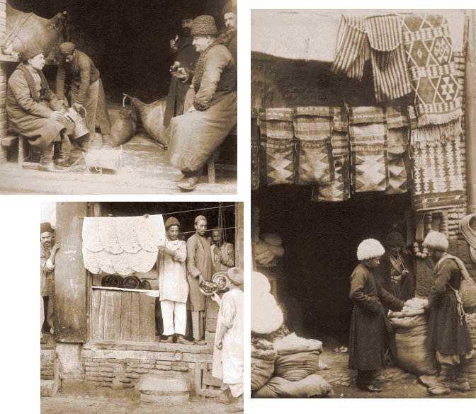
THE BAZAARS OF TBILISI IN THE NINETEENTH CENTURY
Clockwise from top left: A customer tastes a merchant's wine from large animal skins before buying; two men discuss the quality of wool in front of a carpet and wool dealer's shop; a bakery selling thin lavash bread.
If extensive purchases are made (comp. the remarks at p. 463) it is desirable the have the company of an experienced inhabitant, but it should be remembered that guides recommended by the hotels receive a percentage on the sales, which naturally comes out of the pocket of the purchaser. The main rule in buying a number of articles is to offer a lump sum for the whole collection (about ⅔ of the sum demanded in the better shops), and not to pay for each object singly.—The most prized woollen goods come from Daghestan, Kabardá, and Ossetia. Fleecy cloth costs 5-15 rb. per arshin; the Imeretian cloth is distinguished by its bright colours and is cheap (25-30 cop. per arshin).—A good burka (p. 440) costs 12-15 rb., while especially fine and light specimens cost at least 30 rb.—Tiflis is the chief market for Caucasian carpets. As a general rule the Kubá knotted carpets are twice as dear as those from Daghestan. The unknotted carpets are termed zumáks. Genuine old carpets or rugs are steadily becoming dearer and rarer, and the purchaser should be on his guard against imitations.—The weapons of Daghestan still preserve their old reputation, but very deceptive imitations are manufactured in Tiflis. Plain daggers cost 1-3, inlaid with silver 5-12, inlaid with gold 20-50 rb.; old guns inlaid, 50-100 (imitations of the last 10-50) rb.; walking-canes with German silver ornamentation cost 2-5 rb.—Transcaucasian objects include silver belts, often gilded and adorned with enamel, silver azarpéshi (ladles), silver wine-vessels with chasings in the Persian style, and the long necked water-jars of copper.—Tiflis is one of the chief marts in the wine-trade of the Caucasus. Transcaucasia produces yearly 20 million vedros (54,000,000 gallons) of wine. The best wine is that from Kakhetia (Tzinondáli, Mukuzán, Napareuli, &c.), the price of which varies from 25 cop. a bottle up to 1 rb. or more. The red wines are rather harsh.
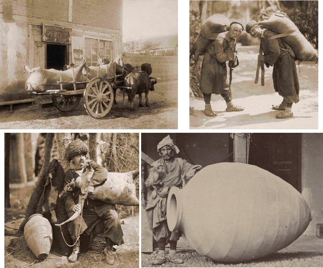
THE WINE TRADE IN NINETEENTH-CENTURY TBILISI
Clockwise from top left: A cart drawn by two oxen laden with skins (Georgian რუმბი, rumbi; quite possibly those of some unfortunate predecessors of theirs) filled with wine; two (probably Tush) men carrying smaller versions on their backs; a man standing next to a yet-unburied clay kvevri in which traditional Georgian wine is made; and a man filling a horn with wine from a goat or sheepskin. Every one of these scenes would have been commonplace in Tbilisi in 1914 (and probably right up to the Second World War).
To the S.E. of the Alexander Garden, on the Kurá, rises the Armenian Vanski Cathedral (Pl. C, 2; II) with its three towers, erected in the early 18th cent. on the site of an older church.—To the S. is the Greek Catholic Antchis-Khatski Cathedral (Pl. C, 3; II), containing an interesting 8th cent. painting of Christ in a costly 13th cent. frame.—Still further to the S., on the Kurá, is the Zion Cathedral (Сионскiй соборъ; Pl. C 4, II), completed in the 7th cent., frequently destroyed in subsequent times, and restored in 1795 et seq. In the interior, to the left of the ikonostás, is a picture of St. Nina, behind which is kept the wooden cross of that saint (not shown to visitors). Near the cathedral is the Museum of Ecclesiastical Antiquities (Церковный музей духовенства Грузинской епархiи), which is open on Tues. & Thurs. 9-11, and on Sun. & holidays 9-1.—To the S. of the Metekhski Bridge are some Baths (Pl. D, 5; II), where the warm carbonated sulphur-springs (99-114°) which rise here are utilized. The best are the Tzikhis-Abáno, belonging to Prince Orbeliáni (bath 1-1½ rb.).
To the W. of the Baths stretch the shady *Botanical Gardens (Ботаническiй садъ; Pl. B, C, 6, II), forming a pleasant refuge from the noise of the streets. They are open from 8 a.m. to 7 p.m., in winter till 4 p.m. (director, A.C. Rollov). The Botanical Museum contains over 2000 objects, including sections of the different trees of the Caucasus, specimens of plant-fibres, fruits, &c. In the remoter part of the garden is a waterfall, and simple refreshments are to be had a little farther up. Admission to the enclosed part of the gardens may be obtained on payment of 5 cop.—On the S. side of the valley is a Mohammedan cemetery, which, however, is hardly worth visiting.—A steep footpath ascends from the Botanical Gardens to the ruins of the Persian Fortress (Pl. C, D, 5; II), which rise picturesquely over the bazaars. [The key of the fort-gate must be obtained from the head-gardener.] In clear weather the fort commands a magnificent view of the town and of the range of mountains dominated by the snowy dome of the Kazbek. To the left of the Kazbek (p. 477) are the pyramid of the Gimarai-Khokh and (farther off) the broad ridge of the Tepli group and of the Adái-Khokh.
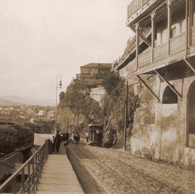
About ½ M. to the W. of the Garrison Cathedral (Pl. A, 2; II) is the lower station of the funicular railway (Фуникулеръ) to the top of Mt. Plóskaya (3270 ft.), which takes 6 min. for the ascent (fare 15, up & down 20 cop.). About halfway up (station; 5 cop.), on the right, is the Georgian Convent of St. David (Pl. A 4, I; 1935 ft.; Мтацминдскiй монастыръ св. Давида Гареджiйскаго). In a grotto close by is the grave of the Russian poet, A.S. Griboyédov (1795-1829). The upper station (restaurant, D. ¾-1 rb.) commands a fine view of the town and mountains, which are seen to best advantage in the morning.
The Metekhski Bridge crosses the Kurá to the GEORGIAN QUARTER on the left bank. Above the bridge rises the Metékh, the former palace of the Georgian kings, now a prison. The only part remaining of the old building is the interesting church (Метехская церковъ; Pl. D 5, II; no admission), which dates from the 5th cent. (dome added in the 13th century).
To the N.E. of the Alexander Garden (p. 468) is the Nicholas Bridge, leading to the Madátovski Island and thence to the left bank of the Kurá. By the bridge stands a bronze statue, by Pimenov (1866), of Prince Vorontzóv (d. 1856; Pl. 10, B 3, I), who conferred various benefits on the town when governor of the Caucasus. The Mikháilovski Prospékt, with the Lutheran Church (Pl. A, B, 2; I), leads hence to the N. through the 'GERMAN QUARTER' (p. 467) to the Railway Station (Pl. A, 1; I). To the W. of the station lies the Mushtaïd Park (Pl. A, 1; I), a popular resort with a Museum of Silk Culture (Pl. 9; open free on week-days 10-2, in winter 10-3).—About 1¼ M. to the N. is the German colony of Alexandersdorf.
About 12 M. to the S.W. of Tiflis (motor omnibus 2, return journey 1½ rb.; phaeton 8 rb.; walking not recommended), high up among the foothills of the Little Caucasus, rises Kodzhóri (4370 ft.), a favourite summer-resort of the residents of Tiflis. Udzó, with an old church, and the ruined fortress of Ker-Ogli both afford fine views of the Little Caucasus, up the valley of the Kurá, and of the high mountains. In the environs of Kodzhori are the ruins of several old Georgian churches, with frescoes and curiously decorated doors and windows (Betáni, Kabenski Convent, &c.). About 7 M. to the S. of Kodzhori is the German colony of Elisabethtal (ca. 3280 ft.; inn).—From Tiflis a motor omnibus runs to the W. viâ Kodzhori, in 3 hrs. (fare 6 rb.), to (40 M.) the summer-resort of Manglis (3935 ft.), situated amid pine-clad mountains.—A highroad runs to the summer-resort of Byeli-Klyutch (4105 ft.), 36 M. to the S.W. of Tiflis. About 3 M. farther on, high over the river Khram, is the ruined castle of Samshvildo.
The interesting convent of Martkóbi, 19 M. to the N.E. of Tiflis (an excursion of two days, phaeton 12-15 rb., saddle-horse 3-5 rb.), was founded about 415 A.D.—Pleasant day-trip also to Mtzkhet (p. 474).
From Tiflis to Batum, see R. 65; to Vladikavkaz (Gruzinian Military Road), see R. 68; to Baku, see R. 67; to Erivan, see R. 73b.—Motor-cars for excursions may be hired from the Société française des transports automobiles du Caucase.
![]()
Route 67
From Tiflis to Baku
515 V. (343 M). Express train in 13 hrs. (14 rb. 50, 8 rb. 70 cop.; reserved seat 1½ rb.; sleeping-car 4 rb. 10, 3 rb. 10 cop.).
Tiflis (Rail. Restaurant), see p. 465. The line runs to the S., along the left bank of the Kurá through a monotonous landscape. 6 V. Navtlúg (1515 ft.; p. 492). At (58 V.) Sogút-Bulákh (800 ft.) the foothills of the Armenian highlands on the right approach to the edge of the Kurá. The train crosses the river before reaching (75 V.) Poili (915 ft.).
89 V. (59 M.) Akstafá (915 ft.; Railway Restaurant).
FROM AKSTAFA TO ERIVAN, 175 V. (117 M.), highroad. A motor omnibus runs via Delizhan in 8 hrs. to (149 V.) Karaklis (p. 193; fare 8 rb.), and another runs from Delizhan viâ Yelenovka in 6 hrs. to Erivan (fare 6 rb.). A four-horse carriage from Akstafa to Delizhan costs 18-20 rb., and thence to Erivan 25 rb. (post-chaise about 15 rb.).—Railway from Tiflis to Erivan viâ Alexandropol, see R. 73 b.
The road ascends to the S.W. through the picturesque Akstafa valley. 9 V. Kazákh, a posting-station; 22½ V. Uzun-Talskaya; 40 V. Karaván-Sarái (accommodation); 58 V. Kars-Tchai. Beyond (72 V.) Delizhán (2200 ft.; R. in the posting-station 1-2 rb.), a prettily situated summer resort, we cross the Tchubukhli Pass (6670 ft.), passing the posting-station of (91 V.) Semyónovka, and reach the *Lake of Goktchá or Sevanga (6315 ft.; trout-fishing), 557 sq. M. in area. Its E. boundary is formed by the high volcanic Karabagh Meridian Mts. As we proceed along the W. bank of the lake, we see to the left, on a rock in the lake, the convent of Sevanga, which is well worth a visit (ferry 3¼ M. on this side of Yelenovka; the night may he spent in the convent). At the village of (112 V.) Yelénovka the road leaves the lake and turns to the W.—
Just beyond the posting-station of (121 V.) Akhti (5690 ft.) the road descends, and a magnificent view opens out before us. On the left is the chain of the Novo-Bayazét, with the volcanic cone of Utchtapalár (10,700 ft.); on the right is the Alagöz (p. 494).—The road now enters the spacious and fertile basin of the Araxes, in which once stood the royal Armenian city of Artaxata.—141 V. Sukhói-Fontán, a posting-station; 160 V. Eilyari, another posting-station.—As we make a steep descent to Eriván (p. 494), the minarets and cupolas of the town appear in front of us, with the massive Mt. Ararat (p. 495) in the background.
From (133 V.) Dzegám (1050 ft.) a road leads to the S. to (25 M.) Kedabék, with the copper-mines and foundries of Siemens Brothers.
177 V. (118 M.) Yelisavetpól (705 ft.; Railway Restaurant), the capital of the district of the same name (1455 ft.; Centrálnaya), lies about 3⅓ M. to the S. of the railway station (tramway 8, izvóshtchik 75 cop,). Pop. 60,000. Before its conquest by the Russians in 1804, the town was called Ganzha. The mosque of Shah Abbas (17th cent.), in the bazaar-square, is surrounded by gigantic plane-trees.—About 8 M. to the S. is the German colony of Helenendorf (1550 ft.).
The line now descends towards the desolate Transcausian Steppe. Most of the rivers which flow from the mountains dry up in this desert, so that the Kurá, reinforced by the waters of the Aráx (Araxes) coming from Armenia, is the only one that reaches the Caspian Sea.—240 V. Yevlákh (30 ft.; Rail. Restaurant), a place with a bad reputation for fever in summer.
FROM YEVLAKH TO NUKHA, 76 V. (50 M.), highroad; motor omnibus in 4 hrs. (fare 4 rb.). The road leads to the N., passing the posting-stations of (14 V.) Khaldán, (25 V.) Tchemakhli, (45 V.) Sutchminskaya, and (59 V.) Ipyaglínskaya.—Nukhá (2455 ft.; Ekonómiya) is a town of 42,000 inhab., with silk-thread factories. In the high-lying citadel is a palace built for the Khans in 1760. To Derbent, see p. 455; to Telav, see p. 489.
FROM YEVLAKH TO SHUSHA, 104 V. (69 M.), highroad; motor omnibus in 6 hrs. (fare 6 rb.; narrow-gauge railway projected). The road leads to the S., passing (23 V.) Bardá, formerly the capital of Albania, with a noteworthy mausoleum. 86 V. Kotcharlinskaya; 50 V. Korvéndskaya; 65 V. Aydám; 80 V. Khodzhalínskaya. All these are posting-stations.—Shushá (Mardi), in the Armenian highlands, a town of 43,000 inhab., with steep and narrow streets, manufactures beautiful carpets (20-400 rb. each).
Immediately after leaving Yevlakh we cross the Kurá. 282 V. Udzhári (40 ft.). The snow-covered mountains of Daghestan now appear on the left.—320 V. Kyurdamir (20 ft. below sea-level).
FROM KYURDAMIR TO SHEMAKHA, 69 V. (46 M.), highroad. 18 V. Kara-Sakhkál; 33 V. Akh-Su, where pomegranates and peaches are wonderfully cheap in autumn; 51 V. Seradilskaya.—Shemaikhá (2230 ft.; accommodation at the Shemakhinski Zayészhi Cathedral; food at the Shemakhinskoye Artistitcheskoye Obshtchestvo), a finely situated hill-town, with 23,000 inhabitants. The town carries on the manufacture of silk scarves (1 rb.) and shawls (5-35 rb.).
307 V. Adzhí-Kabúl (30 ft.; Rail. Restaurant). The railway now turns to the N. and from (430 V.) At-Bulákh (30 ft. below sea-level) onwards runs along the shore of the Caspian Sea (on its right), skirting the S. spurs of the Caucasus. The landscape has the aspect of a desolate wilderness, in which from time to time rise scattered hills or mountain-chains. Beyond (459 V.) Sangatchál (60 ft. below sea-level) the line often runs quite close to the sea. 484 V. Putá, with mud-volcanoes; 502 V. Baladzhári (160 ft.; Rail. Restaurant). Railway to Petrovsk and Rostov, see R. 63.
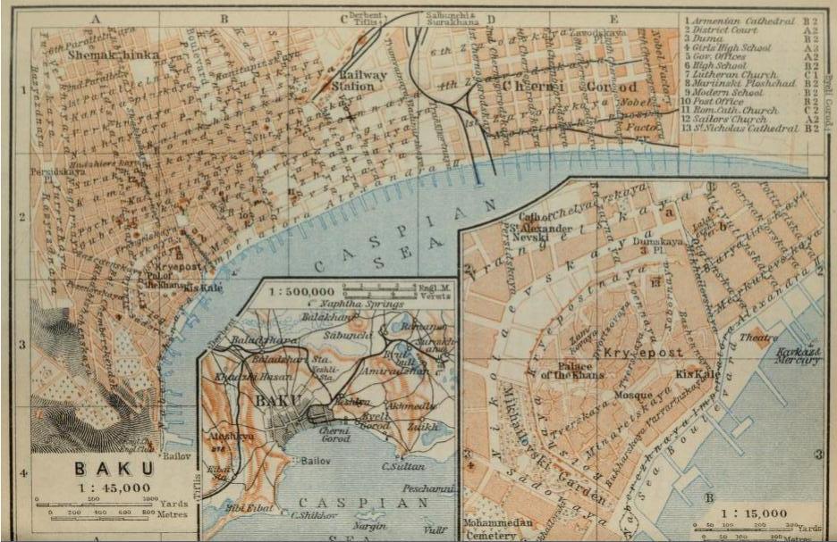
515 V. (343 M.) Bakú (55 ft. below sea-level), see p. 456.
Route 68
From Tiflis to Vladikavkaz
(Gruzinian or Georgian Military Road;
Военно-Грузинская Дорога.)
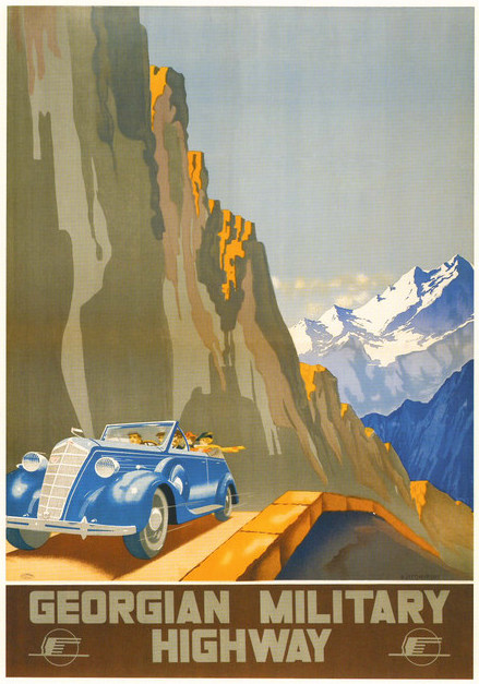
200 V. (132 M.), High Road. MOTOR OMNIBUSES of the Société française des transports automobiles du Caucase ply regularly from April 15th to Oct. 15th; they accomplish the journey in 10 hrs., starting at Tiflis from the office at Olginskaya 46 (Pl. A, 3; I), and arriving in Vladikavkaz at the Grand-Hôtel (fare 20 rb.; to Kazbek 15½ rb.; one pud of luggage allowed free, excess 2 rb. per pud). The company maintains hotels at Kazbek, Dushet, and Passanaur (dinner-station for passengers from Tiflis); the Mail Posting Stations are only for passengers by the mail. Private motor-car 125 rb.—HORSE POSTING ARRANGEMENTS. The posting-rate per horse and verst is 3 cop. In ascending the valley four to six horses are prescribed, in descending three or four. A single traveller should give the driver at each station a fee of 40-50 cop., a party 15-20 cop. each. The best plan is to hire a calèche, which allows the journey to be broken at the traveller's convenience. The charge for a two-seated calèche (Двухмѣстная коляска) with 4 horses is 52 rb. 13 cop., to which must be added a stamp duty of 4 rb. 80 cop. The traveller will do well to hire a so-called conductor, who blows his horn to clear the way and looks after the luggage at the stations (charge 5 rb. for 3 days, with a fee of 1 rb. per day). The Station Rest Houses are built of stone and offer limited accommodation. The best quarters are at Mleti (p. 476) and Kazbek (p. 477; R. with bed-linen and light 1 rb. 40 cop.), but those at Dushet (p. 475), Passanaur (p. 476), Gudaur (p. 476), and Kobi (p. 476) are also tolerable.
The Georgian Military Road, constructed in 1811-1864, is one of the most beautiful mountain roads in the world (height of pass 7800 ft.); the best season of the year is from the beginning of June to the end of Aug. (O.S.). Travellers should pass the night at Kazbek, for the sake of seeing the fine sunrise on the following morning.—Travellers in the reverse direction should leave Vladikavkaz (comp. p. 454) early in the afternoon and also spend the night in Kazbek; hotel-accommodation at Tiflis should be ordered in advance.
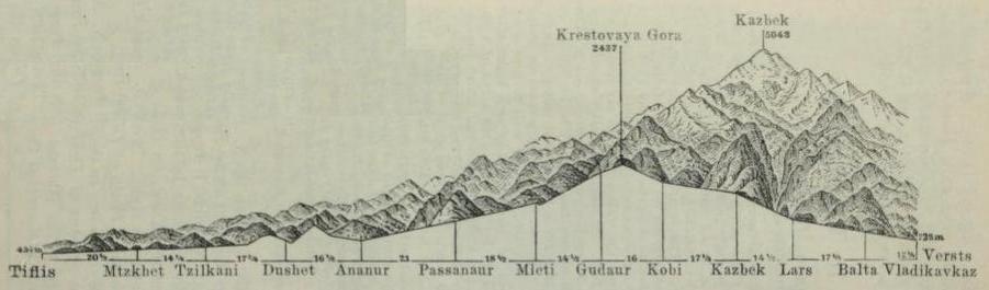
The verst-figures in brackets indicate the distances from station to station.
Tiflis, see p. 465. We leave the town on the N. As we descend to the little river Vera, we see on the right a cast-iron cross which commemorates the escape of Tzar Nicholas I. from a dangerous accident during his journey in the Caucasus in 1837.—The road first runs along the right bank of the Kurá, on the left bank of which Alexandersdorf (p. 471) comes in sight. Then, temporarily leaving the river, it crosses the so-called Plain of Digomi.—After about 13 V. the valley of the Kurá closes in. To the right, on a hill, stands the picturesquely situated convent of Dzhváris-Zakdari, with a church dating from the end of the 7th cent. (?) and said to be built on the spot where St. Nina first erected the cross.
20½ V. Mtzkhet (Мцхетъ; 1600 ft.), a wretched village, lies at the confluence of the Arágva with the Kurá, 2 M. from the posting-station. The latter river is crossed here by a stone bridge. Mtzkhet is one of the oldest places in Georgia, and was the capital of the kingdom before Tiflis. The hill opposite the town once bore the castle of Armás-Tzikhe (p. 443), the most ancient royal residence in the country.—The most important building is the Cathedral of Sveti Tskhoveli, lying to the left of the highroad and surrounded by a lofty crenelated wall with towers. It is said to have been erected in the 4th cent. on the spot where the alleged vesture of Christ was found, brought hither from Golgotha by a Jew; the present building, with a dome over the crossing, dates from the beginning of the 15th century. In this church are buried many of the Georgian kings of the Bagratide dynasty (p. 443), including the last king of all, George XIII. (d. 1801; to the left of the ikonostás). In the apse are some old frescoes that have been restored.—At the end of the village, to the left, is the Nunnery of Samtávro (Самтаврскiй монастырь), with a large church in which Mirian, the first Christian king of Georgia, and his wife lie buried.—In the N.E. part of the cemetery, close by the road, stands an old chapel, on the supposed spot where St. Nina once inhabited her cell.—Every year, on Oct. 1st (O.S.), the inhabitants of the surrounding districts assemble in Mtzkhet for a church-festival, forming an exceedingly interesting ethnographical scene.
Railway to Tiflis and to Batum, see p. 465; the railway station is near the posting-station.
Beyond the convent, on both sides of the road, lies the Necropolis of Samtávro, consisting of two superimposed layers of the remains of tombs belonging to the Iron Age. They are made of slabs of slate in the shape of chests. The skulls found in these tombs are all dolichocephalous, though the present inhabitants of the Caucasus are almost all brachycephalous.—Still farther on, to the right, are the ruins of the fortress of Natzkhóra.—We next pass, by a deeply sunken road, into a fertile district taking its name from the little river of Gartishári, and cross the Karthalinian Plain, to—
35¼ V. (14¾ V.) Tzilkáni (2835 ft.).
The road begins to ascend slowly and leads along the wide floor of the Arágva valley. In the distance the Kazbek (p. 477) appears for a short time. After 49 V. the small Bazalétskoye Salt Lake becomes visible on the left; beyond, in the distance, to the N.W., is seen the Sedlováya Gorá ('saddle hill'). After this the road begins to descend; just short of Dushet is the station of the French motor omnibuses.
53 V. (17¾ V.) Dushét (2890 ft.; restaurant at the omnibus station). The village of that name, with 2600 inhab., lies to the E. of the posting-station. It was the former residence of the Eristave, i.e. viceroys, of the Arágva domain, and was frequently contended for in their feuds with the Georgian kings. Relics of these early times remain in the shape of an old tower (said to have belonged to the viceregal palace) and the ruins of a fortress; the St. Nicholas Church is also old.
The road ascends between fields for 4 M. to a mountain ridge, from which it descends, passing several Georgian and Ossetian villages, into the valley of the White Arágva (Бѣлая Арагва). A few miles farther down, the river is augmented by the waters of the Pshavo-Tchevsurian Arágva.—Passing some deserted barracks, we come to—
69¼ V. (16¼ V.) Ananúr (2695 ft.), picturesquely situated at the junction of the two valleys, and overlooked by the ruins of a fortress (to the left of the road), comprising within its walls two old churches, the remains of a viceregal residence, and a watch-tower. The posting-station is at the N. end of the place.
From Ananur to Telav, see p. 489.
The scenery adjoining the road becomes more and more mountainous. The river rushes more wildly, and the wooded mountains on either side rise higher and higher.
90¼ V. (21 V.) Passanaúr (3335 ft.; hotel-restaurant of the omnibus company, R. from 1½, déj. from 1 rb.), in a narrow valley at the confluence of the Black (Чëрная) and the White Arágva.
The road ascends on the right bank of the White Arágva. Here and there on the steep slopes are hamlets with old churches and half-destroyed towers. The mountains attain a height of 11,500 ft.
108¾ V. (18½ V.) Mleti (4635 ft.), situated high above the foaming waters of the White Arágva, with a meteorological station.
Just beyond Mleti the road crosses the Arágva and ascends in 18 curves along the almost perpendicular rocky walls of the valley; the rocks are covered with huge streams of lava and often assume the form of columns. A marble tablet at the lowest curve of the road commemorates the construction of this section in 1857-61. Fine views are had to the right and left of the valley and of the Georgian hamlets clinging like swallows' nests to the steep slopes, in the midst of fields and Alpine pastures. We see the Red Mts. (Красныя горы) and (as we continue to ascend) the Seven Brothers (Семь братьевъ), both groups consisting of volcanic, red-tinted rocks. The road now makes a slight ascent to—
123¼ V. (14½ V.) Gudaúr (7080 ft.), with a meteorological observatory. Even in June the snow often lies quite thickly here.
The road now leads upwards along the edge of giddy precipices (protected in places by walls and galleries against avalanches or landslips), between Mt. Gud (Гора Гудъ; on the right) and Mt. Krestóvaya (Kpectовая Гора; 8000 ft.; on the left). At last, amid verdant Alpine pastures, we attain the summit of the Krestóvi Pass (variously estimated at 7695 ft. and 7815 ft.), which is designated by a small obelisk on the left, and by a cross, said to have been erected by Queen Tamara, on the right. Beyond the top of the pass the road slowly descends; and we pass by an abrupt transition from the imposing, yet lovely, scenery of the S. slope to the bald and severe mountain region of the N. The following section of the road, especially where it bends to the N. and descends into the Baidára Gorge, skirting one of the affluents of the Terek, is somewhat dangerous in winter and spring on account of frequent avalanches, although protected in places by long snow-sheds. When there has been much snow, it is better to pass over it early in the morning or in the evening. Numerous carbonic and ferruginous springs appear in this region. The massive head of the Kazbek (p. 477) now appears.
139¼ V. (16 V.) Kobi (6340 ft.). The rest-house lies at the foot of a lava-stream, at the confluence of three small rivers, of which the most important is the Terek proper, issuing from the Trusso Gorge.
The valley, which is framed by sheer and barren mountains, now grows broader. Where the cliffs are less precipitous they are occupied by the small hamlets of the Ossetians and the Georgians, with their occasional square towers. Halfway between Kobi and Kazbek, the road bends round the old fortress of Sión, situated on a lofty rock, adjoining a large hamlet with a noteworthy ancient basilica in Georgian style. Farther on, the view into the wide valley of the Tzno opens up on the right.
156½ V. (17¼ V.) Kazbék (5625 ft.; Grand-Hôtel, a dépendance of the hotel of the same name in Vladikavkaz, with a restaurant and view-terrace, R. 2-5, B. ¾, déj. 1-1½, D. 1½-2½, pens. 7-9 rb.). Those who spend the night at the posting-station should select a room with a view of the Kazbek (charges, see p. 473). The fountain in front of the station-building commemorates the visit of the Tzarina Marie Feódorovna in 1888. The village of Kazbek and the large hamlet of Gergéti, lying opposite it on the W., are inhabited by Georgian mountaineers, who maintain themselves by agriculture and cattle-raising and by hunting the tur or Caucasian ibex; the children collect rock-crystals. Near the village church is the grave of the Georgian poet Prince Alexander Kazbek (d. 1893), marked by a monument consisting of a marble model of Mt. Kazbek, with a bronze bust of the poet.
To the W., opposite the village, rises the gigantic ice-pyramid of *Mt. Kazbék, once an active volcano, the E. peak of which (16,545 ft.; Mt. Blanc 15,780 ft.) may be seen in clear weather in all its glory; in the afternoon it is generally veiled in mist. The W. peak is not visible from the posting-station. It was to Mt. Kazbek, according to the myth, that Prometheus was fastened (other versions mention the Elbruz). A magnificent *View of the Kazbek, especially at sunrise, is to be had from the ruined Church of Tzminda-Sameba ('Holy Trinity'; 7120 ft.; reached on horseback in 1½ hr., on foot in 2 hrs.; horse 2, guide 1-1½ rb.). Above the church grows the Caucasian rhododendron, which blossoms in June. It is also well worth while to proceed from the church as far as the foot of the Or-tzferi Glacier (9625 ft.; 2 hrs. riding), whence a superb view is obtained of the Terek valley.
The Kazbek is best ascended from Gveleti (p. 478) viâ the Dyevdorák Hut (p. 470) and the Yermólov Hut (guide 20-25 rb.; to the Yermólov Hut 3 rb., or, if the night is spent out, 5 rb.). The following guides are recommended: Levan Alibekov, Yegor Kizilkov, Ilya and Levan Kushayev, and Illico Khutziev. Porters receive 2-3 rb. daily. From the Dyevdorák Hut (p. 478), we proceed viâ the (1½ hr.) Dyevdorák Glacier (lower end ca. 7525 ft.) to the (3½ hrs.) Yermólov Hut (Ермоловская хижина) of the Russian Mountain Club (11,420 ft.; food, wraps, and water must be provided by the traveller), built in 1903 on the Bart-Kort Arête. From this point we reach the summit in 6½-7½ hrs. viâ the 1st Volgishka, passing the rock known as Pronessi Gospodi, and being on our guard against falls of stones. We descend in 3½ hrs. to the Yermólov Hut, and in 3 hrs. more to the Dyevdorák Hut. The first ascent of the Kazbek was made in 1868 by D.W. Freshfield, A. W. Moore, and C. C. Tucker, who attacked it from the S. side and found it difficult. 1st Day. Ascent to the W. from the posting-station; after 6 hrs., camp was pitched for the night on the S. side of the Or-tzferi Glacier (see above), at a height of ca. 10,820 ft. 2nd Day. To the foot of the ice- wall between the two peaks in 3¾ hrs.; after a climb of 4 hrs. more the saddle was reached, and in 1½ hr. more the E. peak.—In 1891, owing to the good condition of the snow, G. Merzbacher ascended the Kazbek on the N. side, from the mineral springs in the Genaldon Valley, in 12 hrs., descending in 5 hrs.
Beyond the station of Kazbek the road crosses the Terek by an iron bridge, passes two basalt caves 1¼ M. farther on (above, to the left), and then proceeds in windings along the margin of a wide bulge made by the Terek Valley, first ascending slightly and then falling rather rapidly. The road is hewn in the rocks, the vertical and sometimes even overhanging walls of which attain a height of more than 300 ft.; on the right yawns the deep abyss.—Near the old village of (7 V.) Gveléti are a bridge over the Terek and a guard-house (4625 ft.).
Saddle-horses (2½ rb., with guide; porter 1-1½ rb.) or an arba (p. 445; 3 rb.) may be obtained at the guard-honse for an excursion to the Dyevdorák Hut (Девдоракская хижина; 7710 ft.; accommodation for travellers, 12 beds), situated 2 hrs. (8 V. or 5¼ M.) to the W.; for the ascent of the Kazbek from this point, see p. 477.
On the farther side of the bridge begins the *Daryál Gorge (Дарьялское ущелье) or 'Gate of the Alani', the Portae Caspiae (Porta Caucasica) of the ancients, which is about 5 M. long and at its narrowest for ca. ⅔ M. beyond the bridge. Its rocky walls tower perpendicularly above the floor of the valley to a height of 5900 ft., and there is barely room for the road alongside of the river, which here penetrates a secondary chain of the main mountain-range, the average height of which (14,430 ft.) is still 3280 ft. above the snow-line. A little farther on we obtain to the left a *View of the Dyevdorák Glacier and the Kazbek. A small fort guards the end of the gorge, and on a rocky pinnacle opposite to it on the left are the ruins of the Castle of Tamára, which has no connection with the famous Queen of Georgia (p. 443) beyond a similarity of name.
Between Kazbek and Lars, in the height of summer, the traveller will often meet Khevsurs (p. 441) in their striking costume, consisting of gaily coloured and ornamented cloaks, with embroidered crosses fastened on the breast and shoulder. They offer for sale embroidered tobacco-pouches, gloves, satzeruli (knuckle-dusters), sabres, and (occasionally) shields.
171 V. (14½ V.) Lars (3610 ft.). Just before reaching this place we cross a bridge leading to the left bank of the Terek. Beyond the posting-station, which is hemmed in by lofty walls of rock, the huge Yermolóv Stone (Ермоловскiй камень), 95 ft. long, 50 ft. wide, and 42 ft. high, rises from the river.
About 2 M. beyond the posting-station of Lars the road touches at the village of the same name, and soon after it enters the Dzherákhovskoye Gorge. Numerous watch-towers appear on projecting rocks. The gorge gradually widens. About halfway to Balta the Dzherákhovski Fort is seen on the right, and the village of Tchmi on the left, the latter containing three prehistoric burial-grounds and vaults (säppäds).
From TCHMI to UNAL, bridle-path (provisions necessary). We proceed to the W. to (10 hrs.) Dargavsk, with an old necropolis and a view of the glaciers to the S. [About 6 M. to the N., at the hamlet of Koban, is another necropolis.] Continuing towards the W. for 3-4 hrs. more, we reach Dallakau, 2 M. to the N. of which is Dzivgis, with an old Ossetian sanctuary. From Dallakau we reach Unal (see below) in 5-6 hrs., via Khidikús amd the pass of Dzhimi-Avtzag (fine view).
188 V. (17 V.) Balta (2690 ft.).
The road gradually descends along the left bank of the Terek, between low wooded hills. The mountains recede, especially on the right. At the former fort of (5 V.) Redánt we obtain our first view of the plain and town of—
200 V. (12 V.) Vladikavkaz (2345 ft.; p. 454).
Route 69
From Vladikavkaz to Kutaïs viâ the Mamison Pass
(Ossetian Military Road; Военно-Оссетинская Дорога.)
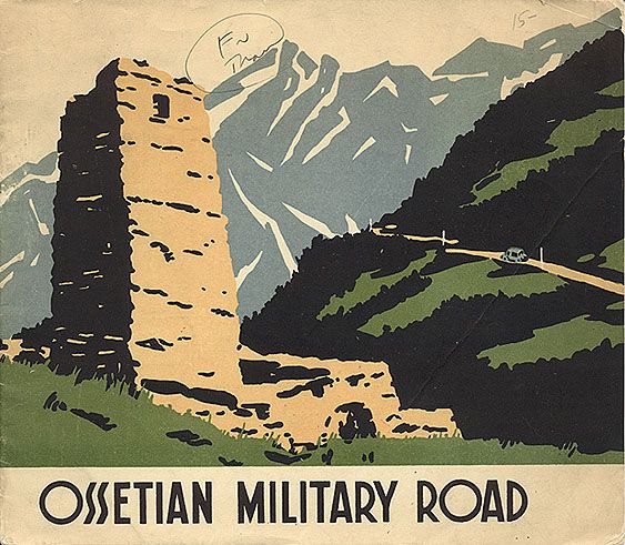
283 V. (188 M.). The trip takes 5 days by carriage. This road is more attractive than the Georgian Military Road so far as scenery is concerned, but the surface is in a very bad state of repair. The journey from Vladikavkaz to Kutaïs is more interesting than in the reverse direction; trustworthy attendants and horses can also be found at Alagir more easily and cheaply than at Oni or Kutaïs. The best travelling-season is July and August (O.S.). It is desirable to have introductions to the engineers of the road at Vladikavkaz (for the N. part) and Kutaïs (for the S. part).
We may go by railway from Vladikavkaz to (42 V.) Darg-Kokh (p. 454) and thence take a lineika (5-6 rb.) via (11 V.) Ardonskaya to (27 V.; 16 V. from Ardonskaya) Alagir. Or we may go from Vladikavkaz to (52 V.) Alagir direct by carriage (10 rb.); but in this case the traveller should stipulate for the route via Arkhonskaya and Ardonskaya in order to avoid the somewhat dangerous drive through the Ardon.—From Alagir to Oni (4 days) we proceed either on horseback (3 rb. daily), or in a lineika (20-25 rb. daily) or a 'droga', an open, springless vehicle of a very primitive character. The traveller must take his own provisions with him, which are best bought in Vladikavkaz; an arba should be hired to carry the luggage (p. 445; 3 rb. daily; passengers should take 1-2 rb. from the coachman as a security, but should not themselves give any earnest-money). From Oni a post-chaise (2 horses; ca. 15 rb.) may be taken to (111 V.) Kutaïs; but lack of horses at the posting-stations often causes wearisome delay. There is also an omnibus in 18 hrs. (fare 4½ rb.).—A phaeton from Kutaïs to Vladikavkaz costs 150-175 rb.
Vladikavkáz, see p. 454. The road leads to the N.W. through the steppe viâ (17 V.) Arkhónskaya and (35 V.) Ardónskaya (7½ M. to the S. of Darg-Kokh, p. 454), whence it runs to the S., through the Ardón valley, to (52 V.) Alagir (2050 ft.; Bellevue, R. 1½ rb.; linéika to Svyatoi Nikolai 8-10, there & back in 3 days 15 rb.).—The road begins to ascend the valley of the Ardón, along the left bank of that river. Near the little village of (70 V.) Biz (2810 ft.; 205 inhab.) rises the Káriu-Kokh (11,160 ft.). 76 V. Unál, see above. Beyond the Gulák-Dukhán (3165 ft.) the valley turns to the W. We soon roach the (80 V.) confluence of the Sádon (3530 ft.) with the Ardón.
On the right, about 3 M. above the junction of the Sádon, in a side-valley, lie the copper-works of Sádon (4160 ft.). From Sádon to Stuir-Digor, see pp. 181, 485.
The valley of the Ardón becomes more and more beautiful. Soon after crossing the bridge over the Sadón we reach the ancient hamlet of (84 V.) Nuzál, the 'cradle of the Ossetians', possessing a quaint old church built of unhewn blocks of stone, and interesting fortifications dug out of the solid rock. The road now runs S. along the right bank of the Ardón, following the E. slope of the Adái Kokh (p. 488), whence the Karagóm glacier (p. 488) descends to the N.W. and the Tzeya glacier to the E.
89 V. (59 M.) Svyatói Nikolái (3745 ft.), the first halting-place for the night for passengers coming from Alagir. Accommodation may be found in the shelter-house of the Vladikavkaz Mountain Club or in the house of the engineer, who will also give information as to guides to the Tzeya Glacier (2 rb. there & back, including a saddle-horse; if the night is spent out, 3 rb.).
The Tzeya Glacier (Цейскiй ледникъ; 6755 ft. high at its lower end and 6 M. long) lies 18 V. (12 M.) to the W. of Svyatoi Nikolai (on foot there & back in 2 days). The expedition is well worth making. The route leads through the wooded *Tzeya Valley, passing the hamlets of Nizhni Tzei (5670 ft.) and (4 hrs.) Verkhni Tzei (5740 ft.). About 4 M. from Verkhni Tzei lies Rekóm, the sanctuary of the Ossetians, a log-cabin the exterior walls of which are hung with the antlers and skulls of deer, wild-goats, and ibexes (no admission to the interior). About 10 min. beyond Rekom is the Sanatorium Hotel, open from June 1st to Aug. 15th (0.S.; R. 1-1½ rb.). The foot of the glacier in reached 2 M. farther on.—The new footpath to Rekom through the Tzeidon Valley is easier and shorter, but there is no view (to the glacier 12 V.).
Beyond Svyatoi Nikolai the road enters the imposing *Khassará Gorge (2¾ M. long, with remains of old fortifications), and just after passing the hamlet of (99 V.) Zaramág or Saramág (accommodation in the Nomerá Kryépost; fine view of the Kaltber; to Gori, see p. 485) turns to the W. into the Mamisón Gorge. The gorge widens considerably as it reaches (107 V.) the hamlet of Tib on the left; retrospect of the peaks of the Tepli Group, p. 488; in front are the Khalatza and other mountains. The road reaches the (115 V.) barracks (nightquarters) lying at the foot of the pass, and crosses the—
123 V. Mamisón Pass (Мамисонскiй перевалъ; 9265 ft.; small shelter), the highest pass practicable for carriages in the Caucasus (Stelvio, 9055 ft.). From a mountain-ridge to the S., several hundred feet higher, a magnificent *View is obtained, especiallv at sunrise, extending to the Shkara (p. 488) and the Ushbá (p. 480).
The road descends in windings through the valley of the Tchantchakha, traversing beautiful woods of silver fir and beech and passing near an engineer's house. 137 V. Gurshévi (6325 ft.), on the left; 147 V. Glola (4630 ft.), on the right (accommodation in the engineer's house).
About 16 V. to the N.W. of Glola, up the Rión valley, is the village of Gebi (3385 ft.; accommodation in the kantzelyáriya). For the Edena Pass and the Tzikhvarga, see p. 488. To the S. of Gebi (1-1½ day) rises the Shoda (11,840 ft.).
We traverse the valley of the Rión. At (160 V.) Utzéri (3475 ft.; hotel) is a carbonic ferruginous spring.—We continue along a shadeless route to (172 V.) Oni (2515 ft.; hotel), a posting-station on the left bank of the Rión.
The highroad descends along the beautiful valley of the Rión. 193 V. Tzossi (posting-station); 215 V. Tola (posting-station); 230 V. Alpani (posting-station; accommodation at the posting agent's). To Svanetia, see R. 70.
Beyond Alpani the road leads through several picturesque gorges, by which the Rión has found its way through the limestone rocks of the mountains. 247 V. Mekvéna (posting-station); 261 V. Namokhováni (posting-station).—Through woods and between luxuriant vineyards and orchards we at length reach (283 V.; 188 M.) Kutaïs (p. 463).
Route 70
Svanetia
Alpani, on the Mamison Road, is the starting-point for a visit to Svanetia or Suanetia, the name applied to the upper valleys of the Ingúr, bounded on the N. by the Central Caucasus, and on the S. by the Láila Ranqe (13,150 ft.) and its spurs. The N.E. part, with the communities of Ushkúl, Kal, Adish, and Muzhál, is the so-called Free Svanetia; the N.W. part, with the communities of Latal, Betcho, etc., takes its name from the princely family of Dadesh-Keliani, which has its seat here.—The extensive forests of deciduous trees and the meadows and fields of Svanetia form a pleasing contrast to the rocky and snowy walls of the Central Caucasus towering to the N. The villages still retain their numerous watch-towers (40-80 ft. high), generally whitewashed, and there are many small churches.
August is the best travelling-season. Accommodation may be had at the kantzelyáriyas (p. 446) or in the school-houses. Provisions should be taken for the whole journey.—Map, see p. 485.
FROM ALPANI TO KAL, 85 V. (57 M.), a ride of 3 days, with the nights at Tzagéri and Tcholúr.—Alpani, see above.—The road leads to the N. through the picturesque Ladzhanuri Gorge, crosses the low watershed between the Rión and the Tzkhenis-Tzkali, and descends, passing Orbéli, a prettily situated place with an old castle, to (19 V.) Tzagéri (accommodation at the dukhán), the seat of a district-chief (Уѣздный начальникъ). This is a good place to hire horses.—We then proceed through magnificent woods, along a bridle-path on the right bank of the Tzkhenis-Tzkali, viâ (27 V. from Tzagéri) Lentékhi (2410 ft.) to (19 V. from Lentékhi) Tcholúr (3320 ft.).
FROM LENTEKHI TO LATAL. We proceed to the W. to (2½ hrs.) Kheláde and thence to the N. to (8-9 hrs.) Skimeri. In 4-5 hrs. more we reach the Láila Pass (ca. 10,800 ft.), with its glaciers, whence a view may be had of the Elbruz and the Dongúz-Orun. We next descend in 2½ hrs. to a saddle some 1640 ft. lower, with a fine view by morning light of Svanetia and the crests of the high mountains. In 2 hrs. more we reach Tzkhomúri, and 4-5 hrs. more bring us to Latál (see below).
From Tcholur we make a steep zigzagging ascent through beech-woods (6½ hrs., not including halts) to the Latpári Pass (9285 ft.; passable from July till the beginning of Oct.).
The *View (mostly clear at sunrise only) from the top of the pass (or still better from a point situated to the E., some 3OO ft. higher) embraces, on the N., the S. side of the central range (with its towering peaks and glaciers), the serrated walls of the Shkara (p. 488) and of the Dzhanga-Tau (p. 488), the bold pyramids of the Gestóla (p. 488) and the Tetnúld (p. 488); on the W., the green mountain-chains of Free Svanetia; on the N.W., the double peaks of the Ushbá (p. 486) and the huge mass of the Dongúz-Orun (p. 486).
From the N. side of the pass we descend in windings to the village of Kal (5735 ft.; accommodation in the kantzelyáriya or in the dukhán).
To the N. of Kal is the village of Iprari, the watch-towers of which were destroyed by the Russians in 1876.
The path from Kal viâ Muzhál, Mestia, and Betcho to Zugdídi (p. 450; 4-5 hrs.) is practicable for horses as far as Betcho, but beyond that for walkers only.
To the E. of Kal, up the valley of the Ingúr (2 hrs. riding), lies the community of Ushkúl (6760 ft.; accommodation at the school-house), consisting of three villages, with 50 watch-towers, two old castles, and a church containing many interesting antiquities.
From Ushkul the lower end of the Shkara Glacier (7835 ft.) can be reached on foot in 8 hrs.—A day's excursion to the *Tzéna Valley is well worth making.
FROM KAL TO LATAL, a ride of two days by a bridle-road through the valley of the Ingúr.—Kal, see above. The route leads to the N.W. as far as the village of Ipar (accommodation in the kantzelyáriya).
From Ipar a bridle-path leads to the E. through the valley of the Adísh-Tchala to (3 hrs.' ride) the village of Adísh (6690 ft.); about ¼ hr. higher up are an interesting church and the grand Adísh Glacier (lower end 7450 ft.). Tetnúld, see p. 488.
From Ipar we may also proceed to the N. over the Uguir Pass (6300 ft.) to (2 hrs.' ride) the village of Mulákh (5500 ft.); a little to the E. of this lies Muzhál (accommodation at the priest's house; Tyuber Pass, see p. 487).
Beyond Ipar the landscape grows hilly; to the S. is a fine view of the Láila (p. 488).—Latál (4310 ft.), a community consisting of several villages, is the lowest inhabited spot in Free Svanetia. To Lentekhi, see p. 481.
About 3 M. to the N. of Latal lies the village of Betcho (accommodation at the kantzelyáriya), the seat of a pristav (police-official), whence a view of the Ushbá (p. 486) is obtained to the N. Horses and porters are not always to be had. To Urusbievo, see p. 486.
Etzéri, to the S.W. of Betcho (a ride of 2½ hrs.), is the seat of Prince Dadesh-Keliani. To the S. is the Láila; its N. peak (13,045 ft.) was ascended in 1889 by D. W. Freshfield and C. H. Powell, the middle peak (13,155 ft.) was scaled in the same year by V. Sella, and the S. peak (13,105 ft.), in 1891, by G. Merzbacher and L. Purtscheller. To the N.W. of Etzeri lies Tchubikhevi (p. 186).
From Latal a road leads to the N.E. up the valley of the Mulkhra, passing Lenzher, with frescoes on the exterior of its church, to Méstiya (4490 ft.; accommodation in the kantzelyáriya), a village with about 70 watch-towers. This is a walk of 3 hrs. Farther to the E. lies Mulakh (p. 482). From Mestiya to Urusbievo, see p. 486.
Route 72
Kakhetia, Daghestan
Several highroads lead from Tiflis to Kakhetia, a district composed of the valleys of the Yora and the Alazán. Railway from Tiflis to Signakh and Telav under construction.
FROM TIFLIS TO TELAV, 95 V. (63 M.), highroad, motor omnibus in 6 hrs. (5 rb.).—Tiflis, see p. 465.—The road leads to the E., at first through a monotonous hilly country. 10 V. Orkhéevi.—24 V. Vaziáni.
About 8 V. (5 M.) to the E. of Vaziani is Marienfeld (2885 ft.), a German colony. From here a highroad leads to the E. through the valley of the Kakhetian Yora, 66 M. long and 5-20 M. wide, viâ (35 V.) Kakabéti, a Georgian village on the left bank of the Yora, to (74 V., or 49 M.) Signakh (see below). The valley of the Alazán is the chief wine-growing district of Kakhetia, the whole country producing yearly 6,600,000 gallons of wine, chiefly red.
Beyond Vaziani the road runs to the N., through pretty country, crossing the watershed between the Yora and the Alazán at a height of 5545 ft., and passing the posting-stations of (41 V.) Udzharma, (61 V.) Gambori, and (77 V.) Tetris-Tzkale.
95 V. Teláv (2420 ft.; Seméinuiye Nomerá), an old town of 17,700 inhab., is beautifully situated on the right bank of the Alazán in the midst of a fertile country, and is the seat of a district chief (Уѣздный начальникъ). It has some remains of fortifications.
About 5 M. to the E. of Telav (phaeton there & back 3-4 rb.) lies the imperial domain of Tzinondáli, where the best wine in Kakhetia is produced.—The church of Alaverdi (Алавердскiй соборъ), situated 8 M. to the N.W. of Telav (phaeton there & back 5-6 rb.) and dating from the 10th cent., is visited on Sept. 14th. (0.S.) by hordes of pilgrims. On this occasion the traveller will have an opportunity of studying the types of the mountain-tribes of Khevsurs, Tushes, Kists, etc.—An interesting excursion of 4-5- days may be made from Telav on horseback, viâ Gremi and across the Kodór Pass (7850 ft.), to Temir-Khan-Shurá (p. 455). Gremi, once the residence of the Kakhetian kings, is now an insignificant village.—A highroad leads to the N.W. from Telav, viâ (25 V.) Akhmeti and (55 V.) Tionéti, to (82 V.) Ananur (p. 475).—A rough road, practicable only on foot or on horseback with a trustworthy guide, runs from Telav along the left bank of the Alazán, viâ (51 V.) Kvareli, Satzkhenisi, and the Aldiakho Pass, to (6-7 days) the Avarian town of Koi-Su.
FROM TELAV TO NUKHA, 211 V. (140 M.), highroad (motor omnibus from Tiflis to Lagodekhi viâ Bakurtzikhe, 165 V. in 8 hrs., fare 9 rb.).—Teláv, see above; 16 V. Akuri; 30 V. Mukuzán (1720 ft.); 47 V. Bakurtzikhe.
62 V. Signákh (2590 ft.; Kakhétiya), a district-town with 16,000 inhab., picturesquely silinilcd on a lofty projecting rock, possesses the ruins of a fortress. In a nunnery is the Sepulchral Church of St. Nina, said to date from the 4th, but as a matter of fact probably from the 6th century. St. George's Chapel commands a fine view. Signakh is reached by carriage from Telav in 6-7 hrs., but may also be reached from Tiflis direct (103 V. or 68 M.) by motor omnibus in 6 hrs. (6 rb.). Highroad to Marienfeld, see p. 489.
Beyond Signakh the highroad runs first to the E. At (70 V.) Tznoris-Tzkali it turns to the N., crosses the Alazán and leads through fine forest viâ (90 V.) Tchaúri to (104 V.) Lagodékhi (Restaurant in the Military Club).—121 V. Byelokáni, a village inhabited by Lesghians; 143 V. Zakatáli (1785 ft.; accommodation at the club); 162 V. Gyillyúk.—177 V. Kakhi (2600 ft.), whence we take the highroad viâ (198 V.) Nizhni Geinyúk to (211 V.) Nukhá (p. 472). Or we may go on horseback in 3-4 days viâ Yelisú, Saruibásh and the Salavat Pass to the district in which the Samúr takes its rise, and on to Akhtí (p. 456).
Unless stated otherwise or obviously not the case, all the text and images on this website are © A.J.T. Bainbridge 2006-2015
Do get in touch! Gmail: alexjtb