
*
The villages of
Georgia's northern regions of
Khevi—Mtiuleti—Gudamaq'ari—Pshavi—Khevsureti—& Tusheti
ხევი, მთიულეთი, გუდამაყარი, ფშავი, ხევსურეთი, & თუშეთი
(including არხოტი, შარახევი, ქვემო ფშავი (მაღაროსკარისკენ), ივრის ფშავლები, ბაკურხევი, &c.)
plotted on Google Earth
with the help of
secret Soviet-era maps
as well as the maps at the end of
old (1930s) Georgian ethnographic books
*
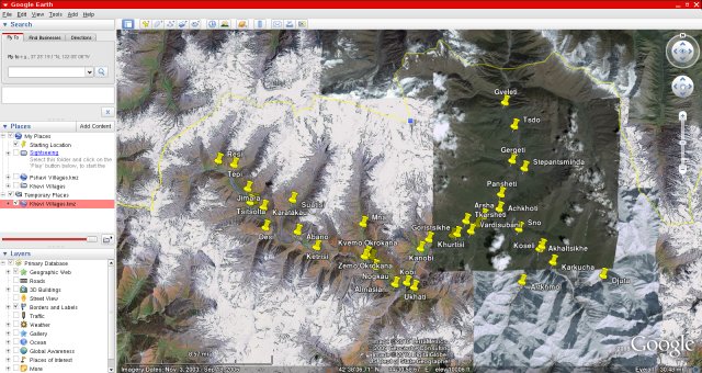
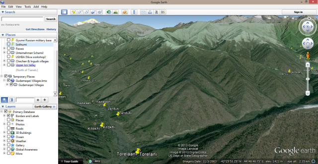
Google Earth is a truly amazing tool: with the help of various maps, ethnographic and topographic, I have laboriously attempted to plot the exact positions of all the villages, hamlets and settlements of several regions of Georgia—viz. K h e v s u r e t i (including Arkhoti and the Shatili & Ardoti valleys); P s h a v i (Pshavi "proper" as well as "lower Pshavi", which includes the Sonda and Shara valleys); K h e v i (better but improperly known as 'Kazbegi', including the Truso gorge); T u s h e t i's Chaghma, Tsovata, Gometsari and Pirikiti communities; and M t i u l e t i (including the Gudamaq'ari valley system and the Khada gorge)—and have saved this information as downloadable '.kmz' files, which can be opened with Google Earth.
Yet, despite the occasionally excellent resolution of the satellite imagery G.E. offers, its coverage of the specific regions we are interested in is, perhaps inevitably (Sod's First Law), often very poor; the area one really wants to be detailed is always the worst.
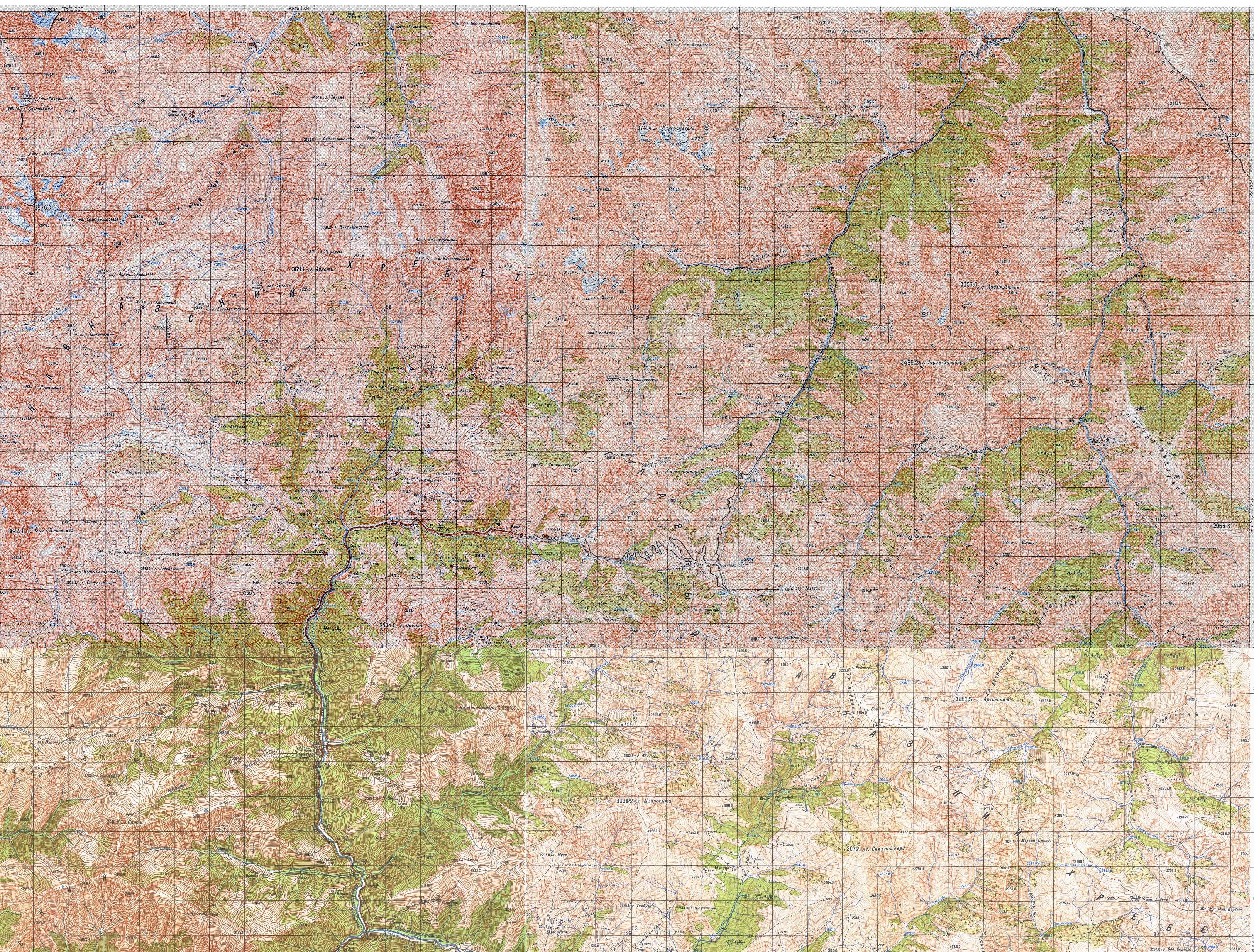
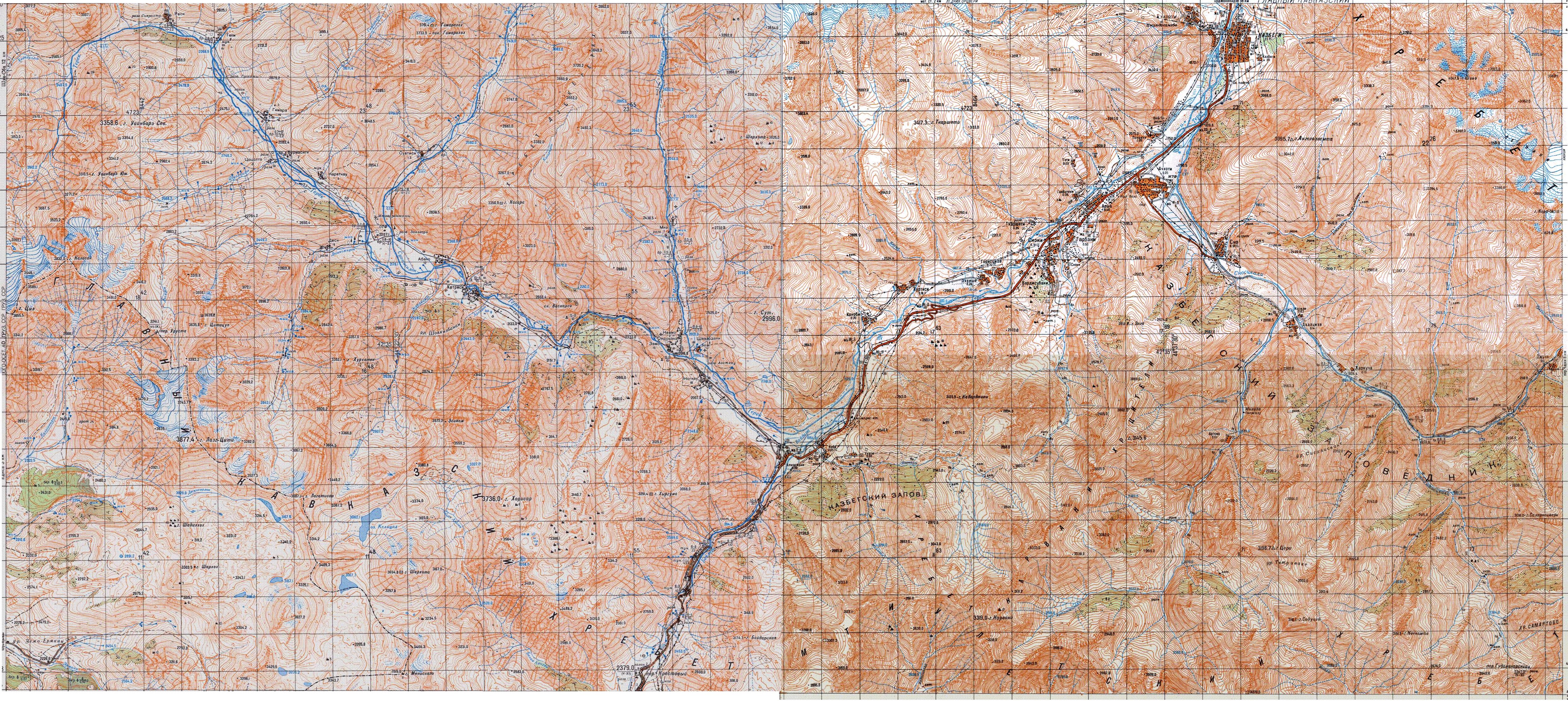
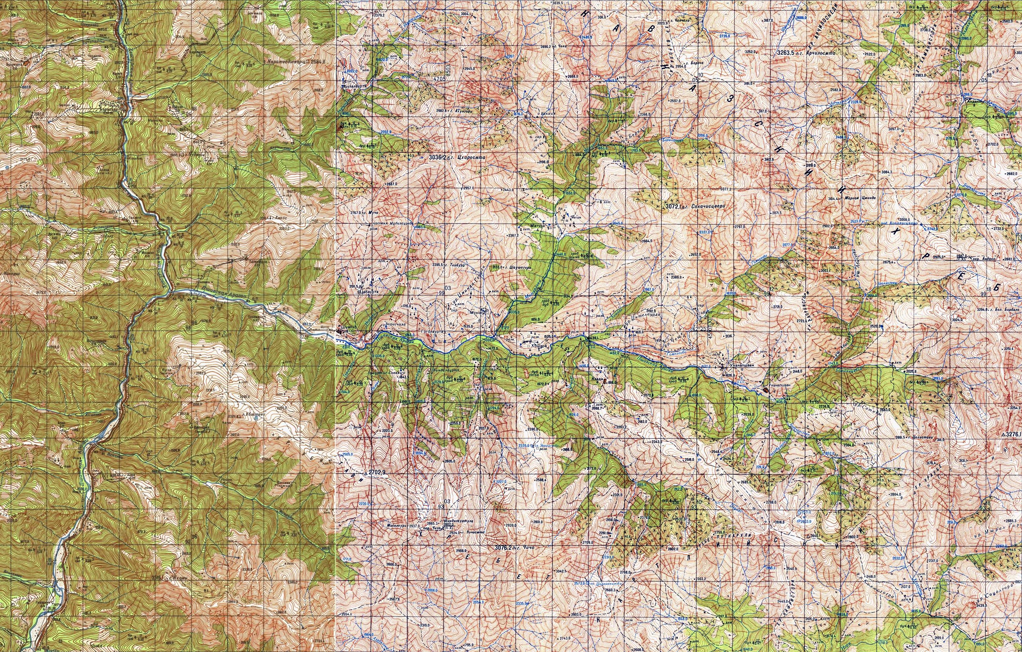
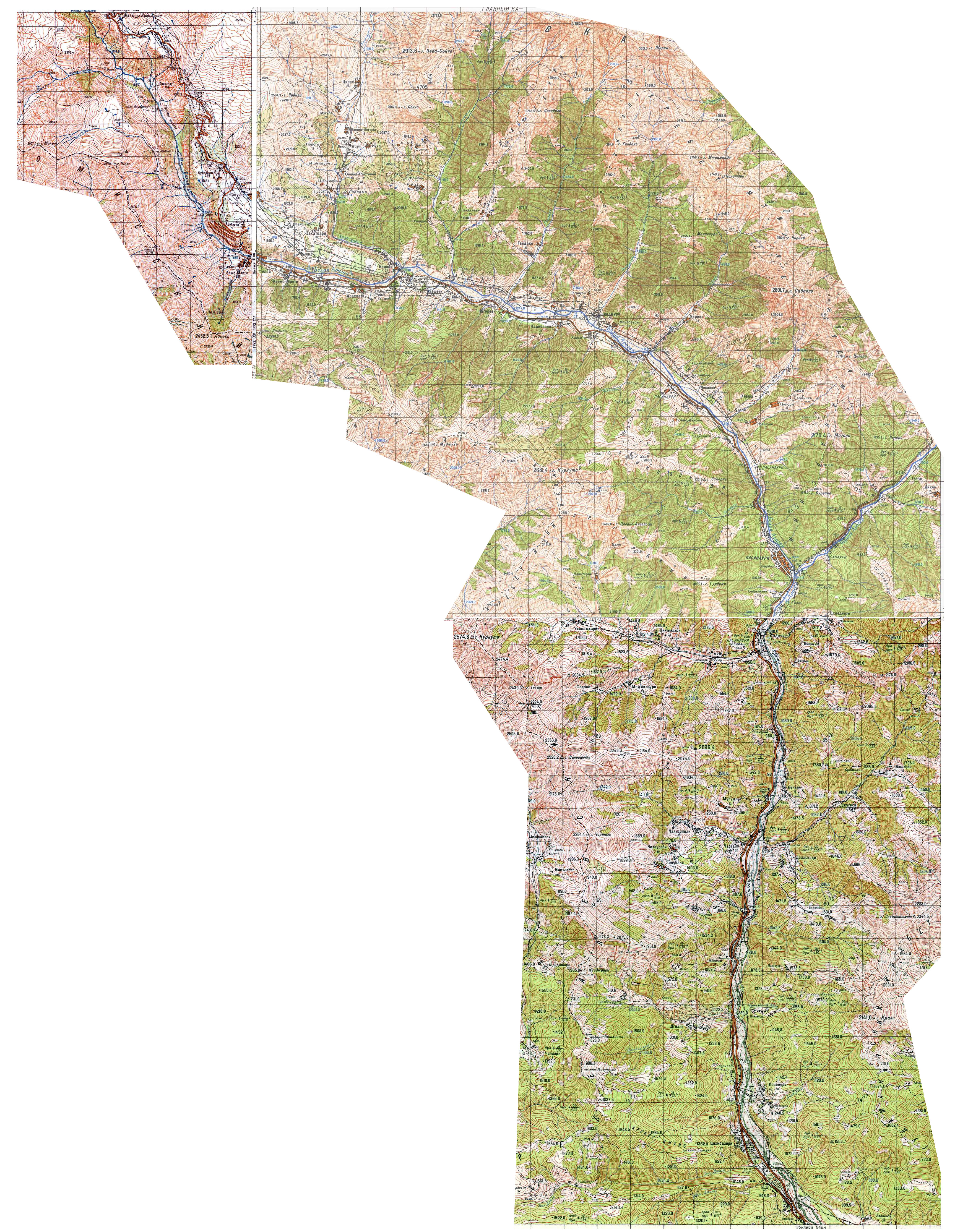
The topographic maps at our disposal were part of the Red Army's outstandingly detailed 1:50,000 series; classified as 'secret', they painstakingly reproduce every curve of the landscape and plot the position of almost every house and ruin. Overall, they are a rock-solid benchmark for exercises such as this, and their detail obviously exceeds anything we found in the series of monographs on these regions written by Sergi Makalatia, a noted Georgian ethnographer, in the 1930s—viz. Pshavi (published in 1934), Khevsureti (1935), Mtiuleti (1930), &c. (under 'M' in the bibliography on this website). All the Soviet general staff maps of the Caucasus and beyond, with scales ranging from 1:50,000 to 1:1,000,000, can be purchased online, e.g. from mapstor.com.
On a more sombre note, however, one should not forget that many of the villages and settlements plotted in these '.kmz' files no longer exist. Rural exodus has, of course, hit these regions particularly hard: deprived of economic opportunities, schools, hospitals, shops and even roads, many villages are no more, and Khevsureti, Tusheti, Gudamaq'ari, &c. are mere shadows of their former selves.
|
* |
* |
* |
|---|
Jump to:
Khevsureti — Khevi — Pshavi — Lower Pshavi — Tusheti — Mtiuleti — Gudamaq'ari
Khevsureti — ხევსურეთი
'Piraketi' (Batsaligo and Barisakho communities) and 'Pirikiti' (Shat'ili and Arkhoti)
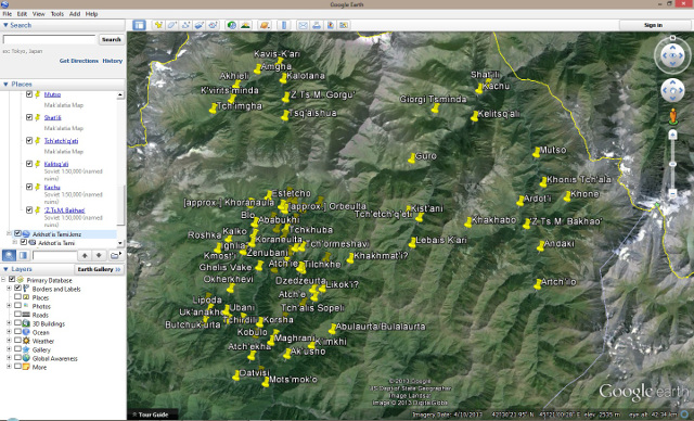
Thanks to the brilliant but somewhat vague map at the end of my copy of Sergi Makalatia's Khevsureti (Komunisti Stamba, Tbilisi: 1935), I spent a couple of happy hours trying to find all the villages on the map in Google Earth. I have followed Makalatia's classification, and have grouped villages together into 4 "temi" (Georgian: თემი) - a territorial union of villages which could perhaps be compared to a parish or a municipality, in the sense that the villages share certain common institutions e.g. a shrine, a "temi" council to decide matters which concern all the villages, &c.
Please download and open the four ".kmz" files with Google Earth to see the villages in situ.
|
Barisakho "temi" (ბარისახოს თემი) — |
Batsaligo "temi" (ბაცალიგოს თემი) — |
|---|---|
|
— |
— |
I have also uploaded a scan of the 1:50,000 Soviet military map of Khevsureti (please click on the image for a higher definition 7MB file). (Note: Unfortunately, the map does not include the northernmost part of Khevsureti viz. in Arkhoti it stops just north of the village of Akhieli, and it does not show the confluence of the Argun and Andaki rivers just north of Shatili.)
Khevi — ხევი
usually but improperly called 'Kazbegi', including the Truso gorge and Sno valley
download file: googleearth-khevi.kmz
|
Main valley
Achkhot'i (აჩხოტი) |
Sno Valley
Akhaltsikhe (ახალციხე) |
Truso Valley
Abano (აბანო) |
|---|
I have also uploaded a scan of the 1:50,000 Soviet military map of Khevi (please click on the image for a higher definition 5.5MB file; the map stops at Stepantsminda/Gergeti, i.e. does not show Tsdo, &c.)
Pshavi — ფშავი
The 'historical' 11 villages, i.e. the main valley.
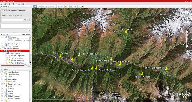
download file: googleearth-pshavi.kmz
The villages:
Akhadi (ახადი), Bindilaurta (ბინდილაურთა), Gogolaurta (გოგოლაურთა), Khoshara (ხოშარა), Matura (მატურა), Muko (მუქო), Shuapkho (შუაფხო), Tchitcho (ჭიჭო), Tkhiliani (თხილიანი), Tsabaurta (ცაბაურთა) & Ukanapshavi (უკანაფშავი).
I have also uploaded a scan of the 1:50,000 Soviet military map of Pshavi (please click on the image for a higher definition 3.5MB file).
'Lower' Pshavi — 'ქვემო' ფშავი
(i.e. Pshavi south of the historical valley itself, including Sharakhevi & Sondiskhevi)
download file: googleearth-lower_pshavi.kmz
I have also uploaded a scan of the 1:50,000 Soviet military map of 'Lower' Pshavi (please click on the image for a higher definition 6MB file).
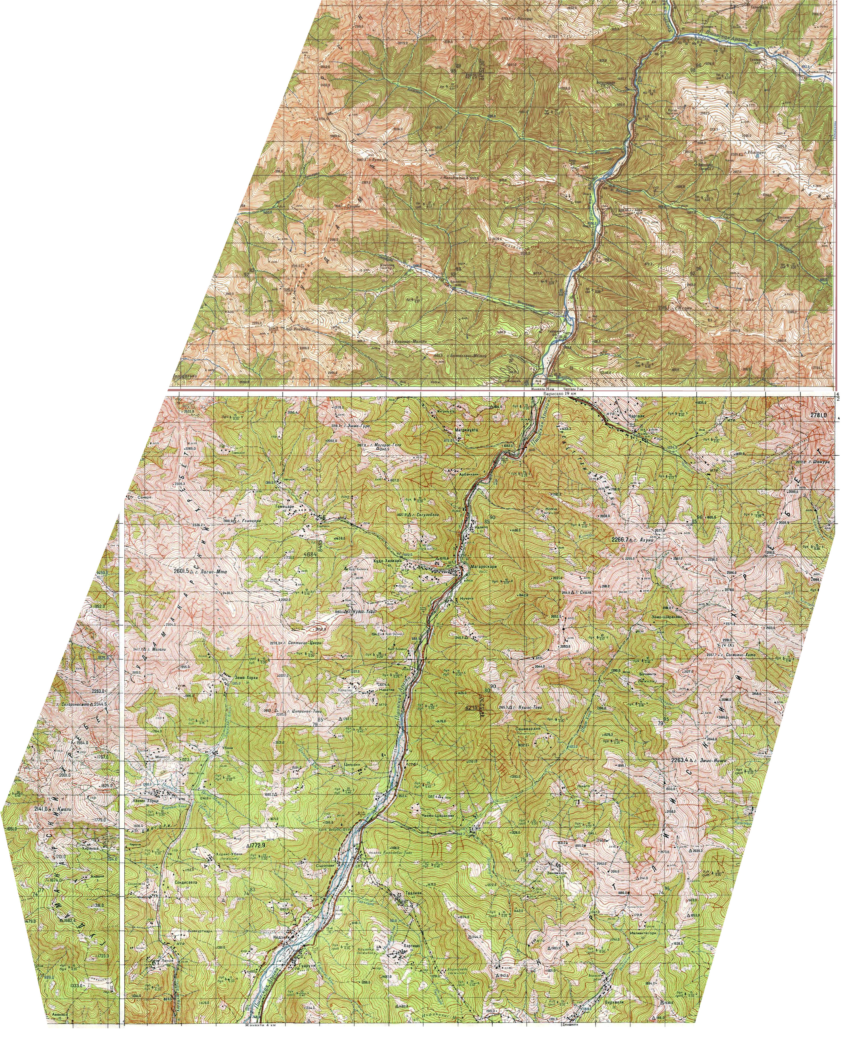
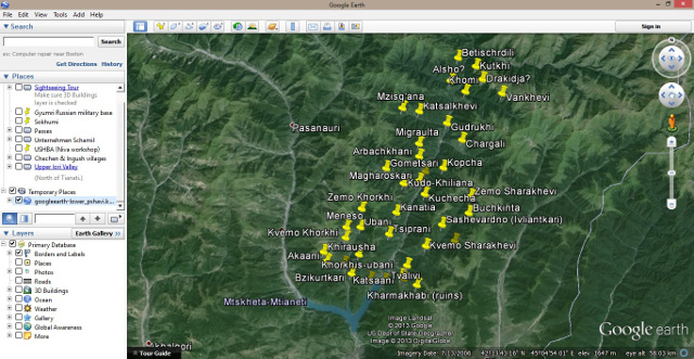
Tusheti — თუშეთი
Gometsari, Pirikiti, Tsova and Chaghma communities
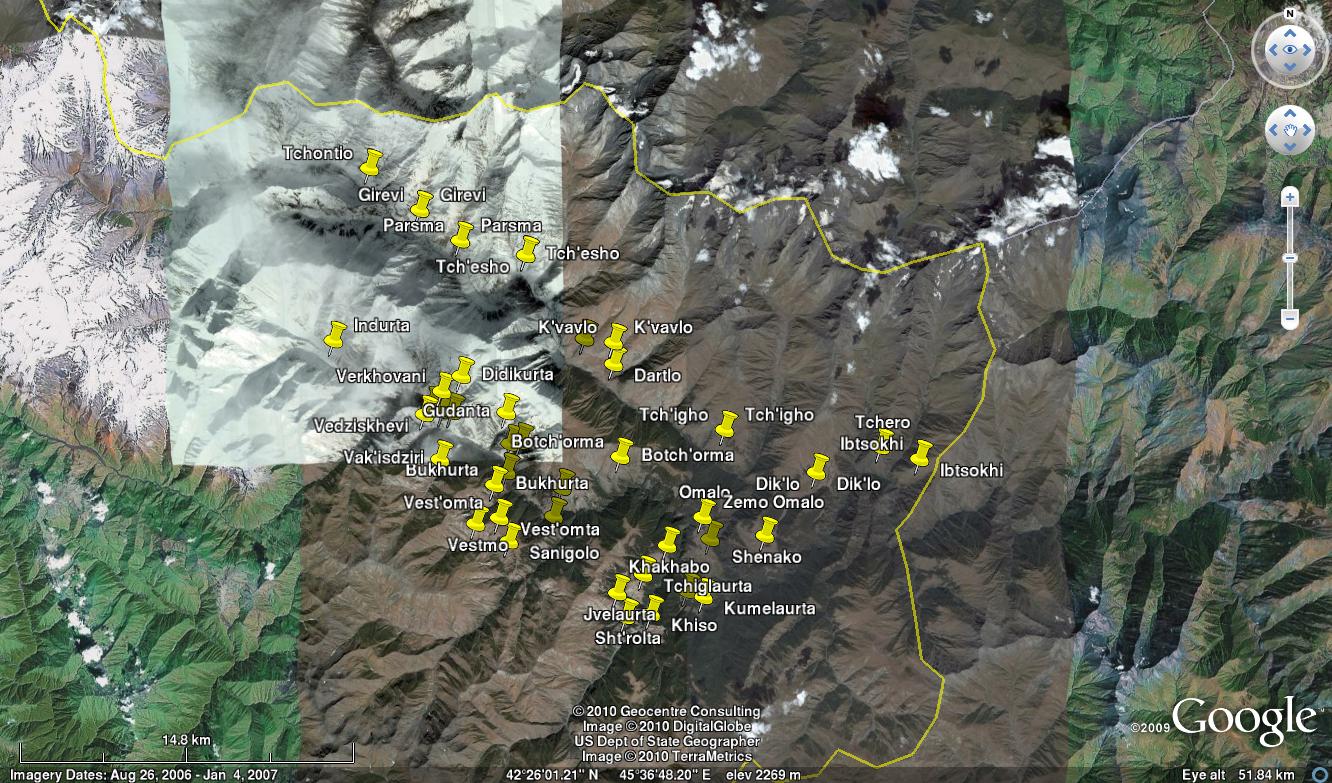
download file: googleearth-tusheti.kmz
The villages:
Alisgori, Beghela, Botch'orma, Bukhurta, Dano, Dartlo, Didikurta, Dik'lo, Djvarboseli, Dotch'u, Girevi, Gogolaurta, Gudanta, Ibtsokhi [abandoned? Under Russian military control.], Iliurta, Indurta [Abandoned.], Jvelaurta, Khakhabo, Khiso, Koklota, Kumblaurta, Kumelaurta, K'vavlo, Omalo, Parsma, Sanigolo, Shenako, Sht'rolta, Tchero [abandoned? Under Russian military control.], Tch'esho, Tch'igho, Tchiglaurta, Tchontio, Vak'isdziri, Vedziskhevi, Verkhovani, Vestmo & Vest'omta
I have also uploaded a scan of the 1:50,000 Soviet military map of Tusheti (please click on the image for a higher definition 12MB file). (Note: The map predates the construction of the current main road to Tusheti by several years. I have roughly marked the path of the "new" road in red; the old one is still used by shepherds, and I doubt it is still motorable.)

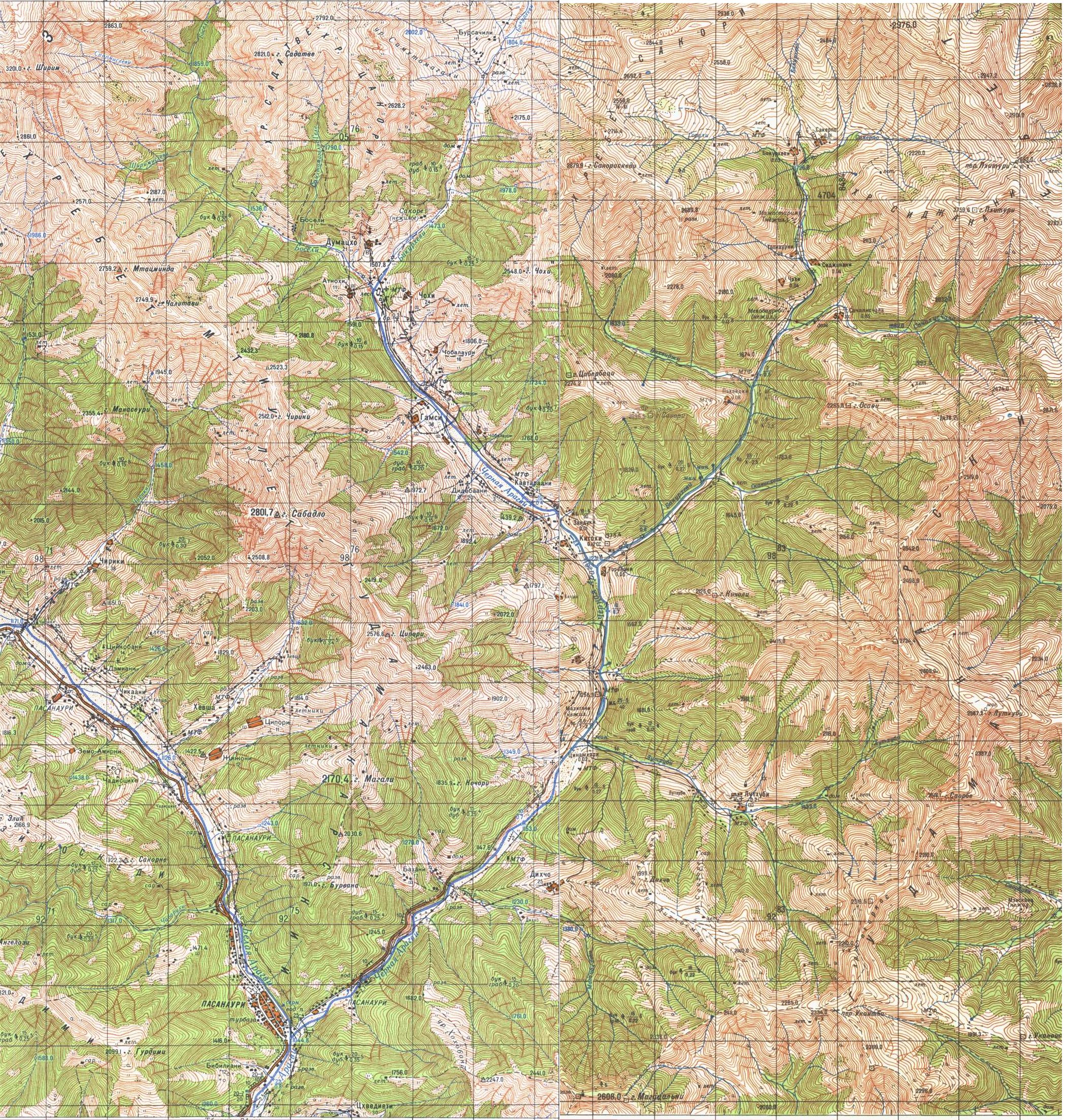
Mtiuleti — მთიულეთი
(including the Khada Gorge)
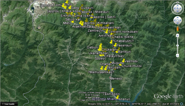
download file: googleearth-mtiuleti.kmz
I have also uploaded a scan of the 1:50,000 Soviet military map of Mtiuleti (please click on the image for a higher definition 6MB file).
Gudamaq'ari — გუდამაყარი
(including the Bakurkhevi branch of the 'fork')
download file: googleearth-gudamaqari.kmz
I have also uploaded a scan of the 1:50,000 Soviet military map of Gudamaq'ari (please click on the image for a higher definition 2MB file).
Unless stated otherwise or obviously not the case, all the text and images on this website are © A.J.T. Bainbridge 2006-2015
Do get in touch! Gmail: alexjtb